IMAGES TAKEN NEAR TO
Cox Ley, BISHOP'S STORTFORD, CM22 7ER
Introduction
This page details the photographs taken nearby to Cox Ley, CM22 7ER by members of the Geograph project.
The Geograph project started in 2005 with the aim of publishing, organising and preserving representative images for every square kilometre of Great Britain, Ireland and the Isle of Man.

There are currently over 7.5m images from over14,400 individuals and you can help contribute to the project by visiting https://www.geograph.org.uk
Image Map
Images are licensed for reuse under creativecommons.org/licenses/by-sa/2.0
Notes
- Clicking on the map will re-center to the selected point.
- The higher the marker number, the further away the image location is from the centre of the postcode.
Image Listing (22 Images Found)
Images are licensed for reuse under creativecommons.org/licenses/by-sa/2.0
Image
Details
Distance
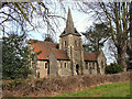
2
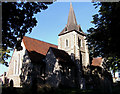
Holy Trinity Church, Hatfield Heath, Essex
Image: © Peter Stack
Taken: 19 Aug 2009
0.15 miles
3
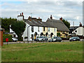
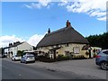
Forge Cottages and a pub, Hatfield Heath
The pub, with the thatched roof, is appropriately 'The Thatchers'. Formerly called 'The Waggon and Horses' (why change?), it is a grade II listed building from about 1580.
Image: © Robin Webster
Taken: 1 Aug 2015
0.18 miles
4
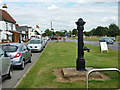
Village pump, Hatfield Heath
It all seems to be there, at least externally, but the handle on the other side is secured.
Image: © Robin Webster
Taken: 1 Aug 2015
0.18 miles
5
The Thatchers pub, Hatfield Heath
This pub used to be called the Waggon and Horses (a much better name in my humble opinion). According to the entry in British Listed buildings dated 1985 (see http://www.britishlistedbuildings.co.uk/en-353638-waggon-and-horses-public-house-hatfield-#.VewX1BFViko)), the original name was still in use. By the time of Robert Edward's photo in 2006 (see http://www.geograph.org.uk/photo/154295)) it had changed its name. I don't know when the name changed in this 21 year period. See http://pubshistory.com/EssexPubs/HatfieldBO/wagonho.shtml for a 1968 photo of the pub when it had an attractive Waggon and Horsessculpured wooded sign outside.
Image: © Bikeboy
Taken: 28 Aug 2015
0.18 miles
6
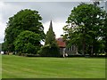
Holy Trinity Church, Hatfield Heath
Built in 1859 when Hatfield Heath parish was formed in its own right instead of belonging to Hatfield Broad Oak.
Image: © Bikeboy
Taken: 7 Jun 2014
0.18 miles
7
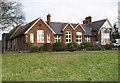
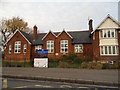
Hatfield Heath Community Primary School
The School, which is on the A1060 Stortford Road, has its website here http://www.hatfieldheath.essex.sch.uk/p_Home.ikml The blue sign states
Essex County Council
Hatfield Heath
County Primary School
so the school has changed from "county" to "community" at some stage in its life.
Image: © Nigel Cox
Taken: 9 Jan 2008
0.18 miles
8
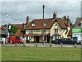
The White Horse, Hatfield Heath
A grade II listed pub, early 17th century.
Image: © Robin Webster
Taken: 30 Jun 2013
0.19 miles
10
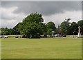
Hatfield Heath
Looking across the cricket field towards the war memorial and Holy Trinity Church
Image: © Bikeboy
Taken: 7 Jun 2014
0.20 miles