IMAGES TAKEN NEAR TO
Blocks Corner, Sparrow Lane, BISHOP'S STORTFORD, CM22 7AY
Introduction
This page details the photographs taken nearby to Blocks Corner, Sparrow Lane, CM22 7AY by members of the Geograph project.
The Geograph project started in 2005 with the aim of publishing, organising and preserving representative images for every square kilometre of Great Britain, Ireland and the Isle of Man.

There are currently over 7.5m images from over14,400 individuals and you can help contribute to the project by visiting https://www.geograph.org.uk
Image Map
Images are licensed for reuse under creativecommons.org/licenses/by-sa/2.0
Notes
- Clicking on the map will re-center to the selected point.
- The higher the marker number, the further away the image location is from the centre of the postcode.
Image Listing (4 Images Found)
Images are licensed for reuse under creativecommons.org/licenses/by-sa/2.0
Image
Details
Distance
1

Tree near Sparrow Lane
Also by a farm track connecting through to Marks Hall Lane.
Image: © Robin Webster
Taken: 30 Jun 2013
0.18 miles
2
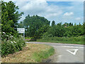
Sparrows Lane meets A1060 Chelmsford Road
The right turn up the main road to the left is plated Sparrow Lane, without an 's'.
Image: © Robin Webster
Taken: 30 Jun 2013
0.18 miles
3
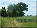
Hedgerow and field north of Grange Farm
Image: © Robin Webster
Taken: 30 Jun 2013
0.20 miles
4
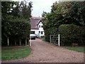
Blocks, east of Hatfield Heath, Essex
Image: © Robert Edwards
Taken: 11 Aug 2006
0.21 miles