IMAGES TAKEN NEAR TO
Ardley End, BISHOP'S STORTFORD, CM22 7AJ
Introduction
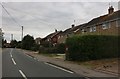
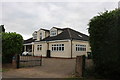
This page details the photographs taken nearby to Ardley End, CM22 7AJ by members of the Geograph project.
The Geograph project started in 2005 with the aim of publishing, organising and preserving representative images for every square kilometre of Great Britain, Ireland and the Isle of Man.

There are currently over 7.5m images from over14,400 individuals and you can help contribute to the project by visiting https://www.geograph.org.uk
Image Map
Images are licensed for reuse under creativecommons.org/licenses/by-sa/2.0
Notes
- Clicking on the map will re-center to the selected point.
- The higher the marker number, the further away the image location is from the centre of the postcode.
Image Listing (4 Images Found)
Images are licensed for reuse under creativecommons.org/licenses/by-sa/2.0
Image
Details
Distance
3
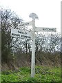
Direction Sign ? Signpost at Ardley End, Hatfield Heath
Located at Ardley End on the southeast side of the T-junction of Matching Road and Friars Lane in Hatfield Heath parish. 3 arms, 1 now missing, and half-moon finial. At some time between this photo and 2012 the replacement arm pointing to Takeley and Bishops Stortford (sic) was lost and it is still missing in 2021.
Milestone Society National ID: EX_TL5214
Image: © John V Nicholls
Taken: Unknown
0.12 miles
4
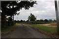
Farm track off Matching Road, Ardley End
Image: © David Howard
Taken: 13 Jul 2019
0.25 miles