IMAGES TAKEN NEAR TO
Clayden Drive, BISHOP'S STORTFORD, CM22 6TY
Introduction
This page details the photographs taken nearby to Clayden Drive, CM22 6TY by members of the Geograph project.
The Geograph project started in 2005 with the aim of publishing, organising and preserving representative images for every square kilometre of Great Britain, Ireland and the Isle of Man.

There are currently over 7.5m images from over14,400 individuals and you can help contribute to the project by visiting https://www.geograph.org.uk
Image Map
Images are licensed for reuse under creativecommons.org/licenses/by-sa/2.0
Notes
- Clicking on the map will re-center to the selected point.
- The higher the marker number, the further away the image location is from the centre of the postcode.
Image Listing (2 Images Found)
Images are licensed for reuse under creativecommons.org/licenses/by-sa/2.0
Image
Details
Distance
1
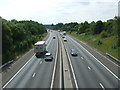
M11 near Elsenham
Here the motorway cuts through Alsa Wood.
Image: © David Beresford
Taken: 8 Aug 2013
0.23 miles
2
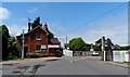
Elsenham Station and level crossing
The railway first came to Elsenham in 1845.
Image: © Bikeboy
Taken: 7 Jun 2014
0.24 miles