IMAGES TAKEN NEAR TO
The Street, BISHOP'S STORTFORD, CM22 6QS
Introduction
This page details the photographs taken nearby to The Street, CM22 6QS by members of the Geograph project.
The Geograph project started in 2005 with the aim of publishing, organising and preserving representative images for every square kilometre of Great Britain, Ireland and the Isle of Man.

There are currently over 7.5m images from over14,400 individuals and you can help contribute to the project by visiting https://www.geograph.org.uk
Image Map
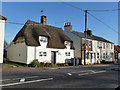
Images are licensed for reuse under creativecommons.org/licenses/by-sa/2.0
Notes
- Clicking on the map will re-center to the selected point.
- The higher the marker number, the further away the image location is from the centre of the postcode.
Image Listing (19 Images Found)
Images are licensed for reuse under creativecommons.org/licenses/by-sa/2.0
Image
Details
Distance
1
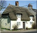
Deep Eaves
On the B1356 in Takeley Street.
Image: © Thomas Nugent
Taken: 16 Mar 2007
0.00 miles
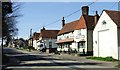
2
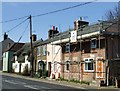
Takeley Street
A house on Dunmow Road being renovated.
Image: © Thomas Nugent
Taken: 16 Mar 2007
0.02 miles
3
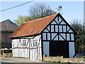
Half timbered building, Takeley Street
Garage on the B1356. Note the weather vane with cats. See Image for a distant shot of this building.
Image: © Thomas Nugent
Taken: 16 Mar 2007
0.10 miles
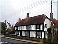
4
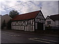
Tudor barn in Takeley Street
The barn appears to be original but the roof is clearly recent.
Image: © David Howard
Taken: 25 Apr 2012
0.12 miles
5
Takeley Street
Looking west along the B1256. See a close-up of the half-timbered building here Image
Image: © Thomas Nugent
Taken: 16 Mar 2007
0.13 miles
6
Tudor barn and cottages on Dunmow Road
Image: © David Howard
Taken: 25 Apr 2012
0.13 miles
7
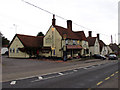
Green Man, Takeley
A welcome rest stop on the (old) A120, close to Stansted Airport.
Image: © Alan Simkins
Taken: 12 Oct 2002
0.14 miles
8
Clock House, Takeley
Clock House is late C16/early C17. See http://www.britishlistedbuildings.co.uk/en-122101-clock-house-takeley-essex for entry in British Listed Buildings.
Takeley is linear settlement along the B1256 which was the A120 until a new dual carriageway was built recently. The route through the village follows the course of the Roman road linking St Albans (Verulamium) and Colchester (Camulodunum).
Image: © Bikeboy
Taken: 15 Feb 2015
0.16 miles
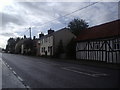
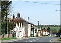
9
Houses, Takeley Street
Lining the north side of the old Roman road, formerly the A120, now the B1256.
Image: © Robin Webster
Taken: 11 Jan 2015
0.17 miles
10
Takeley Street
A varied selection of architectural styles on this stretch of road.
Image: © Thomas Nugent
Taken: 16 Mar 2007
0.20 miles