IMAGES TAKEN NEAR TO
De Mandeville Road, BISHOP'S STORTFORD, CM22 6LR
Introduction
This page details the photographs taken nearby to De Mandeville Road, CM22 6LR by members of the Geograph project.
The Geograph project started in 2005 with the aim of publishing, organising and preserving representative images for every square kilometre of Great Britain, Ireland and the Isle of Man.

There are currently over 7.5m images from over14,400 individuals and you can help contribute to the project by visiting https://www.geograph.org.uk
Image Map
Images are licensed for reuse under creativecommons.org/licenses/by-sa/2.0
Notes
- Clicking on the map will re-center to the selected point.
- The higher the marker number, the further away the image location is from the centre of the postcode.
Image Listing (7 Images Found)
Images are licensed for reuse under creativecommons.org/licenses/by-sa/2.0
Image
Details
Distance
1
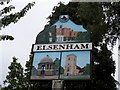
Elsenham village sign
Showing Elsenham Hall, the pump and St Mary's church.
Image: © Bikeboy
Taken: 29 May 2014
0.05 miles
3
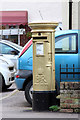
Gold Post Box, Robin Hood Road
Painted gold to celebrate Ben Maher's Gold medal for the Equestrian Team Jumping during the London 2012 Olympic Games.
Image: © Oast House Archive
Taken: 1 Nov 2012
0.15 miles
4
Gold Post Box, Robin Hood Road
Painted gold to celebrate Ben Maher's Gold medal for the Equestrian Team Jumping during the London 2012 Olympic Games.
Image: © Oast House Archive
Taken: 1 Nov 2012
0.15 miles
6
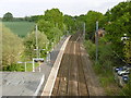
The railway at Elsenham station
The railway line to Cambridge was opened by the Eastern Counties Railway on 30th July 1845 at which date Elsenham station also opened. The station has staggered platforms on either side of the level crossing so that trains pass over the crossing before stopping at the station. This view is from the footbridge which was built in 2007 after two teenage girls were killed crossing the line in 2005 - see http://www.som.cranfield.ac.uk/som/dinamic-content/media/Healthcare%20Management/HDTM%20Research%20Briefing%209%20Elsenham%20Crossing.pdf The up platform is on the left.
Image: © Marathon
Taken: 14 May 2016
0.23 miles
7
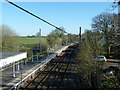
Elsenham station up platform
The down platform is north of the level crossing. During its comparatively brief existence, the Thaxted branch used the far side of the platform for its terminating passenger trains. Through running was not possible, the only connection being a reversal through the goods yard north of the level crossing.
Image: © Robin Webster
Taken: 16 Mar 2014
0.24 miles