IMAGES TAKEN NEAR TO
Old Mead Road, BISHOP'S STORTFORD, CM22 6JQ
Introduction
This page details the photographs taken nearby to Old Mead Road, CM22 6JQ by members of the Geograph project.
The Geograph project started in 2005 with the aim of publishing, organising and preserving representative images for every square kilometre of Great Britain, Ireland and the Isle of Man.

There are currently over 7.5m images from over14,400 individuals and you can help contribute to the project by visiting https://www.geograph.org.uk
Image Map (Loading...)


Getting Data...Please wait
Leaflet Map data © OpenStreetMap
Images are licensed for reuse under creativecommons.org/licenses/by-sa/2.0
Notes
- Clicking on the map will re-center to the selected point.
- The higher the marker number, the further away the image location is from the centre of the postcode.
Image Listing (6 Images Found)
Images are licensed for reuse under creativecommons.org/licenses/by-sa/2.0
Image
Details
Distance


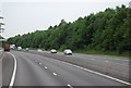
3

M11 northbound near Ugley
Ugley featured in Rude Britain (subtitled 100 Rudest Place Names in Britain) a 2005 book of British place names with seemingly rude or offensive meanings.
Image: © Julian P Guffogg
Taken: 5 Jul 2013
0.19 miles

6

M11 northbound
A featureless stretch of road.
Image: © Robin Webster
Taken: 7 Oct 2011
0.22 miles