IMAGES TAKEN NEAR TO
Cambridge Road, BISHOP'S STORTFORD, CM22 6HR
Introduction
This page details the photographs taken nearby to Cambridge Road, CM22 6HR by members of the Geograph project.
The Geograph project started in 2005 with the aim of publishing, organising and preserving representative images for every square kilometre of Great Britain, Ireland and the Isle of Man.

There are currently over 7.5m images from over14,400 individuals and you can help contribute to the project by visiting https://www.geograph.org.uk
Image Map (Loading...)


Getting Data...Please wait
Leaflet Map data © OpenStreetMap
Images are licensed for reuse under creativecommons.org/licenses/by-sa/2.0
Notes
- Clicking on the map will re-center to the selected point.
- The higher the marker number, the further away the image location is from the centre of the postcode.
Image Listing (8 Images Found)
Images are licensed for reuse under creativecommons.org/licenses/by-sa/2.0
Image
Details
Distance
1
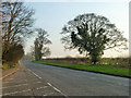
B1383 north of Stansted Mountfitchet
Formerly the A11(T).
Image: © Robin Webster
Taken: 13 Mar 2014
0.02 miles
2
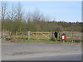
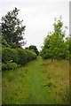
Entrance to Linnets Wood
There is room for a couple of cars to park at this entrance to Linnets Wood.
See also: Path in Linnets Wood http://www.geograph.org.uk/photo/3401392
Linnets Wood was given to the Woodland Trust by in 1992 by Rosalind 'Linnet' Latham. The following is from the Woodland Trust web page: http://www.webcitation.org/6Fj4jJ2Op :
Linnets Wood is small, maturing mixed woodland in the village of Ugley, a few miles north of Stansted. It was planted in three phases - the first two under Essex County Council's Landscape Conservation Programme in 1973 and 1988, and the latter in 1998 as part of the Woodland Trust's 'Woods on your Doorstep' (WOYD) project. The majority of the wood comprises mixed native broadleaves such as oak, ash, hornbeam and wild cherry, all establishing very well.
Image: © Roger Jones
Taken: 7 Apr 2013
0.12 miles
3
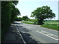
Entrance To Bollington Hall
Driveway of the B1383 leading to Bollington Hall near to Ugley Green, Essex.
Image: © Keith Evans
Taken: 14 May 2018
0.13 miles
4
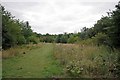
Summer in Linnets Wood
The majority of this land was bequeathed to the Woodland Trust in 1992 http://www.woodlandtrust.org.uk/en/our-woods/pages/wood-details.aspx?wood=4510&site=linnets-wood#.UgdgcZKmjNt. Although some tree planting had begun as early as 1973 a large proportion of this former agricultural land was planted up in 1997/8 as part of the Trusts "Woods On Your Doorstep Scheme" see also http://www.wildessex.net/sites/Linnets%20Wood.htm
Image: © Glyn Baker
Taken: 10 Aug 2013
0.13 miles
5
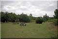
Picnic Spot in Linnets Wood
See Image for more info
Image: © Glyn Baker
Taken: 10 Aug 2013
0.13 miles
6
Old Commemorative Stone by Pound Lane, Ugley Parish
Commemorative Marker by the UC road, in parish of Ugley (Uttlesford District), Hillend, Pound Lane, Ugley, set in outside of brick wall.
Surveyed
Milestone Society National ID: EX_UGLEY01cm
Image: © Milestone Society
Taken: Unknown
0.20 miles
8
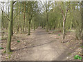
Path in Linnets Wood
See also Entrance to Linnets Wood http://www.geograph.org.uk/photo/3403107
Linnets Wood was given to the Woodland Trust by in 1992 by Rosalind 'Linnet' Latham. The following is from the Woodland Trust web page: http://www.webcitation.org/6Fj4jJ2Op :
Linnets Wood is small, maturing mixed woodland in the village of Ugley, a few miles north of Stansted. It was planted in three phases - the first two under Essex County Council's Landscape Conservation Programme in 1973 and 1988, and the latter in 1998 as part of the Woodland Trust's 'Woods on your Doorstep' (WOYD) project. The majority of the wood comprises mixed native broadleaves such as oak, ash, hornbeam and wild cherry, all establishing very well.
Image: © Roger Jones
Taken: 7 Apr 2013
0.25 miles