IMAGES TAKEN NEAR TO
New Road, BISHOP'S STORTFORD, CM22 6HE
Introduction
This page details the photographs taken nearby to New Road, CM22 6HE by members of the Geograph project.
The Geograph project started in 2005 with the aim of publishing, organising and preserving representative images for every square kilometre of Great Britain, Ireland and the Isle of Man.

There are currently over 7.5m images from over14,400 individuals and you can help contribute to the project by visiting https://www.geograph.org.uk
Image Map (Loading...)


Getting Data...Please wait
Leaflet Map data © OpenStreetMap
Images are licensed for reuse under creativecommons.org/licenses/by-sa/2.0
Notes
- Clicking on the map will re-center to the selected point.
- The higher the marker number, the further away the image location is from the centre of the postcode.
Image Listing (34 Images Found)
Images are licensed for reuse under creativecommons.org/licenses/by-sa/2.0
Image
Details
Distance
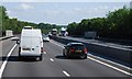
2
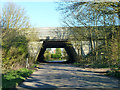
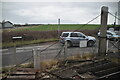
M11 bridge
This style of bridge is frequent where the M11 crosses smaller roads. This one over Bedwell Lane is fitted with sound barriers.
Image: © Robin Webster
Taken: 16 Mar 2014
0.17 miles
6
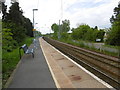
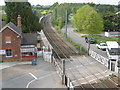
The down platform at Elsenham station
The railway line to Cambridge was opened by the Eastern Counties Railway on 30th July 1845 at which date Elsenham station also opened. The station has staggered platforms on either side of the level crossing so that trains pass over the crossing before stopping at the station.
This view is the down platform. The up platform is behind, beyond the level crossing - see http://www.geograph.org.uk/photo/4950232
Image: © Marathon
Taken: 14 May 2016
0.19 miles
7
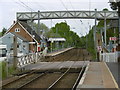
The level crossing at Elsenham station
The railway line to Cambridge was opened by the Eastern Counties Railway on 30th July 1845 at which date Elsenham station also opened. The station has staggered platforms on either side of the level crossing so that trains pass over the crossing before stopping at the station. This view looks towards the footbridge which was built in 2007 after two teenage girls were killed crossing the line in 2005 - see http://www.som.cranfield.ac.uk/som/dinamic-content/media/Healthcare%20Management/HDTM%20Research%20Briefing%209%20Elsenham%20Crossing.pdf This is the down platform and the up platform is beyond the crossing.
Image: © Marathon
Taken: 14 May 2016
0.20 miles
8
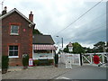
Elsenham level crossing
Part of the old station building is now run as a takeaway.
Image: © Jonathan Billinger
Taken: 20 Jun 2008
0.20 miles
10
View from the footbridge at Elsenham station
The railway line to Cambridge was opened by the Eastern Counties Railway on 30th July 1845 at which date Elsenham station also opened. The station has staggered platforms on either side of the level crossing so that trains pass over the crossing before stopping at the station.
This view is from the footbridge which was built in 2007 after two teenage girls were killed crossing the line in 2005 - see http://www.som.cranfield.ac.uk/som/dinamic-content/media/Healthcare%20Management/HDTM%20Research%20Briefing%209%20Elsenham%20Crossing.pdf This looks across the crossing to the down platform. The up platform is behind, on this side of the level crossing.
Image: © Marathon
Taken: 14 May 2016
0.20 miles