IMAGES TAKEN NEAR TO
Godfrey Crescent, BISHOP'S STORTFORD, CM22 6FU
Introduction
This page details the photographs taken nearby to Godfrey Crescent, CM22 6FU by members of the Geograph project.
The Geograph project started in 2005 with the aim of publishing, organising and preserving representative images for every square kilometre of Great Britain, Ireland and the Isle of Man.

There are currently over 7.5m images from over14,400 individuals and you can help contribute to the project by visiting https://www.geograph.org.uk
Image Map (Loading...)


Getting Data...Please wait
Leaflet Map data © OpenStreetMap
Images are licensed for reuse under creativecommons.org/licenses/by-sa/2.0
Notes
- Clicking on the map will re-center to the selected point.
- The higher the marker number, the further away the image location is from the centre of the postcode.
Image Listing (17 Images Found)
Images are licensed for reuse under creativecommons.org/licenses/by-sa/2.0
Image
Details
Distance
1
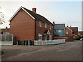
Russel Francis Way, Takeley, near Bishop's Stortford
Russel Francis Way is a recent housing development in the village of Takeley in north Essex.
Image: © Malc McDonald
Taken: 29 Oct 2022
0.05 miles
2
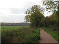
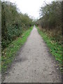
Flitch Way, Takeley, near Bishop's Stortford
Flitch Way heading out of the village of Takeley in north Essex. This image was taken in the late afternoon on an October day, as the daylight was fading. Dusk would soon fall.
Image: © Malc McDonald
Taken: 29 Oct 2022
0.06 miles
3
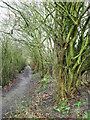
Harcamlow Way at Takeley
Viewed from the Flitch Way which crosses at this point.
Image: © Thomas Nugent
Taken: 27 Feb 2007
0.06 miles
4
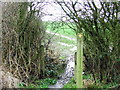
Harcamlow Way at Takeley
Harcamlow Way crosses Flitch Way at this point, looking towards Hatfield Park.
Image: © Thomas Nugent
Taken: 27 Feb 2007
0.09 miles
5
Flitch Way at Takeley
On the trackbed of the now closed Bishop's Stortford, Dunmow & Braintree railway.
Image: © Thomas Nugent
Taken: 27 Feb 2007
0.10 miles
6
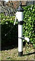
Old hand pump
By the B1256 at Brewers End, Takeley.
Image: © Thomas Nugent
Taken: 16 Mar 2007
0.15 miles
7
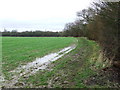
Harcamlow Way at Hatfield Park
Very muddy underfoot due to recent rain. The control tower at Stansted Airport is visible in the distance.
Image: © Thomas Nugent
Taken: 27 Feb 2007
0.17 miles
8
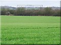
Field at Hatfield Park
Viewed from the Harcamlow Way footpath. The large building in the distance is SR Technics, by Stansted Airport. The line of trees nearest the camera is the line of the now closed Bishop's Stortford, Dunmow & Braintree railway. The Flitch Way footpath now follows this part of the line.
Image: © Thomas Nugent
Taken: 27 Feb 2007
0.17 miles
9
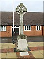
Takeley war memorial
Outside the Silver Jubilee Hall Image]
Image: © Thomas Nugent
Taken: 27 Feb 2007
0.17 miles
10
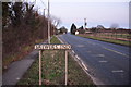
Old A120 at Brewers End, looking east
The now quiet main road towards the village of Takeley.
Image: © MJ Reilly
Taken: 5 Mar 2009
0.17 miles