IMAGES TAKEN NEAR TO
Pledgdon Green, BISHOP'S STORTFORD, CM22 6BN
Introduction
This page details the photographs taken nearby to Pledgdon Green, CM22 6BN by members of the Geograph project.
The Geograph project started in 2005 with the aim of publishing, organising and preserving representative images for every square kilometre of Great Britain, Ireland and the Isle of Man.

There are currently over 7.5m images from over14,400 individuals and you can help contribute to the project by visiting https://www.geograph.org.uk
Image Map
Images are licensed for reuse under creativecommons.org/licenses/by-sa/2.0
Notes
- Clicking on the map will re-center to the selected point.
- The higher the marker number, the further away the image location is from the centre of the postcode.
Image Listing (6 Images Found)
Images are licensed for reuse under creativecommons.org/licenses/by-sa/2.0
Image
Details
Distance
1
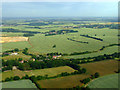
Archaeological dig site near Elsenham from the air
Traces of a large scale dig, possibly related to the groundworks on the left. Viewed from a flight on final approach to Stansted from the northeast.
Image: © Thomas Nugent
Taken: 12 Jun 2011
0.13 miles
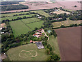
2
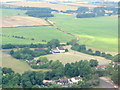
Plegdon Green from the air
Looking northwest on approach to Stansted Rwy22.
Image: © M J Richardson
Taken: 5 Jul 2018
0.14 miles
3
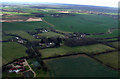
Wood farm from the air
On final approach to Stansted Airport from the east.
Image: © Thomas Nugent
Taken: 19 Mar 2012
0.15 miles
4
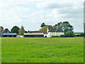
Pledgdon Green Farm
Seen across Pledgdon Green.
Image: © Robin Webster
Taken: 27 Sep 2014
0.16 miles
5
Wood Farm from the air
On the approach to Stansted Airport from the north east.
Image: © Thomas Nugent
Taken: 14 Sep 2015
0.20 miles
6
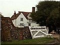
Farmhouse at Wood Farm
This appears to be a very old timber-framed farmhouse, which probably dates back to the early 16th century.
Image: © Robert Edwards
Taken: 23 Oct 2006
0.20 miles