IMAGES TAKEN NEAR TO
Henham, BISHOP'S STORTFORD, CM22 6BL
Introduction
This page details the photographs taken nearby to CM22 6BL by members of the Geograph project.
The Geograph project started in 2005 with the aim of publishing, organising and preserving representative images for every square kilometre of Great Britain, Ireland and the Isle of Man.

There are currently over 7.5m images from over14,400 individuals and you can help contribute to the project by visiting https://www.geograph.org.uk
Image Map
Images are licensed for reuse under creativecommons.org/licenses/by-sa/2.0
Notes
- Clicking on the map will re-center to the selected point.
- The higher the marker number, the further away the image location is from the centre of the postcode.
Image Listing (8 Images Found)
Images are licensed for reuse under creativecommons.org/licenses/by-sa/2.0
Image
Details
Distance
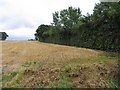
1
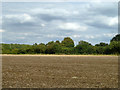
Field near Palegates Farm
The farm grounds are beyond the hedge on the right, but it does not seem to be directly involved in local farming any more.
Image: © Robin Webster
Taken: 27 Sep 2014
0.10 miles
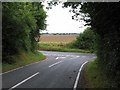
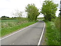
3
Lane to Pledgdon Green
This quiet lane leads away from the B1051, close to Palegates Farm. A footpath just ahead leads to the farm.
Image: © Marathon
Taken: 14 May 2016
0.12 miles
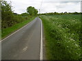
4
Lane to Pledgdon Green
This quiet lane leads away from the B1051, close to Palegates Farm.
Image: © Marathon
Taken: 14 May 2016
0.13 miles
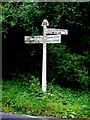
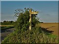
7
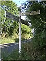
Direction Sign ? Signpost on the B1051 in Henham parish
Located on the southeast side of a T junction on the B1051, east of Pledgdon Hall and north of Pledgdon Green, in Henham parish. 3 arms and half-moon finial. See also https://www.geograph.org.uk/photo/534236.
Milestone Society National ID: EX_TL5627
Image: © John V Nicholls
Taken: Unknown
0.22 miles