IMAGES TAKEN NEAR TO
Rosebery Road, CHELMSFORD, CM2 0TU
Introduction
This page details the photographs taken nearby to Rosebery Road, CM2 0TU by members of the Geograph project.
The Geograph project started in 2005 with the aim of publishing, organising and preserving representative images for every square kilometre of Great Britain, Ireland and the Isle of Man.

There are currently over 7.5m images from over14,400 individuals and you can help contribute to the project by visiting https://www.geograph.org.uk
Image Map
Images are licensed for reuse under creativecommons.org/licenses/by-sa/2.0
Notes
- Clicking on the map will re-center to the selected point.
- The higher the marker number, the further away the image location is from the centre of the postcode.
Image Listing (8 Images Found)
Images are licensed for reuse under creativecommons.org/licenses/by-sa/2.0
Image
Details
Distance
1

St John the Evangelist Church, Chelmsford, Essex
Image: © Peter Stack
Taken: 13 Aug 2010
0.21 miles
3

The First Wireless Factory in the World
The Hall Street works was the first wireless factory in the world. It was built for The Wireless Telegraph & Signal Co and was used for the production of the first wireless receiving and transmitting apparatus. the factory was later named The Marconi Wireless Telegraph Company. The Building is currently up for sale.
Image: © Ken Brown
Taken: 3 Jun 2011
0.22 miles
5
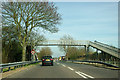
Footbridge over A1114, Princes Road
The road was formerly the A12 and the first attempt at a Chelmsford bypass.
Image: © Robin Webster
Taken: 25 Mar 2012
0.22 miles
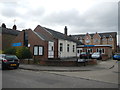
6
Seventh Day Adventist Church, Roman Road
Image: © Paul Franks
Taken: 18 Feb 2013
0.23 miles
7
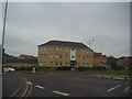
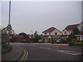
Flats on Burghley Way, Moulsham
At the junction of Princes Road
Image: © David Howard
Taken: 2 May 2012
0.25 miles
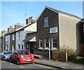
8

Moulsham Street
Moulsham Street follows the course of the Roman road from London to Colchester. There are several listed buildings on the street, some dating to the 16th century or earlier. The white weatherboarded building is late 18th or early 19th century.
Image: © Paul Franks
Taken: 18 Feb 2013
0.25 miles