1
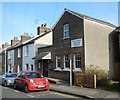
Chelmsford, The Woolpack
2010 Good Beer Guide-listed pub in Mildmay Road. Internally, central L-shaped bar, with drinking areas on three sides. Eight cask ales on offer at my visit, including one on gravity. For some customer comments, see http://www.beerintheevening.com/pubs/s/31/31927/Woolpack/Chelmsford
Image: © Mike Faherty
Taken: 15 May 2010
0.04 miles
2
The First Wireless Factory in the World
The Hall Street works was the first wireless factory in the world. It was built for The Wireless Telegraph & Signal Co and was used for the production of the first wireless receiving and transmitting apparatus. the factory was later named The Marconi Wireless Telegraph Company. The Building is currently up for sale.
Image: © Ken Brown
Taken: 3 Jun 2011
0.04 miles
3
Hall Street Methodist Church
Image: © Paul Franks
Taken: 19 Apr 2013
0.08 miles
4
Seventh Day Adventist Church, Roman Road
Image: © Paul Franks
Taken: 18 Feb 2013
0.09 miles
5
Baddow Road
Part of Baddow Road isolated by later road developments. The building on the left is the Salvation Army Citadel opened in 2009.
Image: © Paul Franks
Taken: 18 Feb 2013
0.09 miles
6
Salvation Army Citadel
Designed by Hudson Architects and opened in 2009, this building won the ACE/RIBA award for Religious Architecture. It replaced a 1970's building.
Image: © Paul Franks
Taken: 4 Mar 2013
0.11 miles
7
Life Church, Hall St
An Elim Pentecostal Church
Image: © Paul Franks
Taken: 18 Feb 2013
0.11 miles
8
Parkway, Chelmsford
Image: © David Howard
Taken: 12 Nov 2023
0.12 miles
9
Premises behind the old Regent, Chelmsford, 1990
These were, at least in part, plumbing suppliers. Now demolished and built over, although the Regent survives as a night club.
Image: © Robin Webster
Taken: Unknown
0.13 miles
10
Former Odeon picture theatre, Baddow Road, 1990
A rear view of the 1748 seat cinema which opened as the Ritz in 1935. It was renamed in 1947 and closed in 1981. This view in early 1990 shows it semi-derelict but so far spared in the redevelopment going on around it. It did not last much longer, and was replaced by a multi-storey car park.
Image: © Robin Webster
Taken: Unknown
0.13 miles


