IMAGES TAKEN NEAR TO
Arkwrights, HARLOW, CM20 3NA
Introduction
This page details the photographs taken nearby to Arkwrights, CM20 3NA by members of the Geograph project.
The Geograph project started in 2005 with the aim of publishing, organising and preserving representative images for every square kilometre of Great Britain, Ireland and the Isle of Man.

There are currently over 7.5m images from over14,400 individuals and you can help contribute to the project by visiting https://www.geograph.org.uk
Image Map (Loading...)


Getting Data...Please wait
Leaflet Map data © OpenStreetMap
Images are licensed for reuse under creativecommons.org/licenses/by-sa/2.0
Notes
- Clicking on the map will re-center to the selected point.
- The higher the marker number, the further away the image location is from the centre of the postcode.
Image Listing (5 Images Found)
Images are licensed for reuse under creativecommons.org/licenses/by-sa/2.0
Image
Details
Distance
1
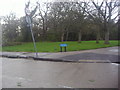
Arkwrights at the corner of Howard Way, Netteswell
Many of the names used in Harlow are continuing the original villages which were there before the new town was built.
Image: © David Howard
Taken: 12 Apr 2012
0.07 miles
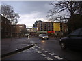
3
St Andrews Methodist Church, Harlow (2)
Taken from Howard Way, this church had its foundation stone laid on Saturday 27th June 1953 with the Grand Opening taking place on Saturday 30th October 1954. It is one of several churches in the Herts & Essex Border Ecumenical Area, which was formed through the coming together of the Lea Valley North Methodist Circuit and the West Essex United Area on Friday 1st September 2006. To the left of the photo can be seen the wording "The Methodist Church" whilst its green noticeboard at the front of the church is to the right.
Image: © David Hillas
Taken: 5 Apr 2018
0.23 miles
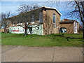
4

St Andrews Methodist Church, Harlow (1)
Situated in The Stow, CM20 3AF, this church is one of seventeen churches in the Herts & Essex Border Ecumenical Area which comprises the Methodist, United Reformed and Anglican Churches in Partnership. Services with Sunday Club and Crèche take place here each Sunday at 10.30am whilst activities are held during the week.
Image: © David Hillas
Taken: 5 Apr 2018
0.24 miles
5
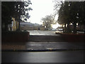
Entrance to Moot House community centre, Minchen Road
Image: © David Howard
Taken: 12 Apr 2012
0.25 miles