IMAGES TAKEN NEAR TO
Halling Hill, HARLOW, CM20 3JL
Introduction
This page details the photographs taken nearby to Halling Hill, CM20 3JL by members of the Geograph project.
The Geograph project started in 2005 with the aim of publishing, organising and preserving representative images for every square kilometre of Great Britain, Ireland and the Isle of Man.

There are currently over 7.5m images from over14,400 individuals and you can help contribute to the project by visiting https://www.geograph.org.uk
Image Map (Loading...)


Getting Data...Please wait
Leaflet Map data © OpenStreetMap
Images are licensed for reuse under creativecommons.org/licenses/by-sa/2.0
Notes
- Clicking on the map will re-center to the selected point.
- The higher the marker number, the further away the image location is from the centre of the postcode.
Image Listing (12 Images Found)
Images are licensed for reuse under creativecommons.org/licenses/by-sa/2.0
Image
Details
Distance
1
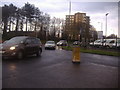
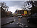
Roundabout on Howard Way and First Avenue, Harlow
Unlike many new towns Harlow has a mixture of original and modern buildings from around the 1960s onwards, including some areas of nice larger houses as well as the typical council types common in many others.
Image: © David Howard
Taken: 12 Apr 2012
0.05 miles
2
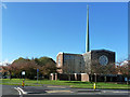
Roman Catholic church, Harlow
Our Lady of Fatima.
Image: © Robin Webster
Taken: 4 Nov 2014
0.06 miles
3
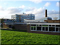
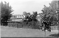
Burnt Mill Comprehensive
Bill Rammell Harlow MP went to school here, as did Glen Hoddle England player and manager.
Image: © Roger McLachlan
Taken: 21 Oct 2006
0.07 miles
4
Our Lady of Fatima RC Church, Harlow, Essex
Image: © Peter Stack
Taken: 7 Jun 2009
0.08 miles
5
St Alban's RC Primary School, 1971
Seen from a bus on First Avenue.
Image: © Penny Mayes
Taken: 1 Jan 1971
0.09 miles
6
St Andrews Methodist Church, Harlow (2)
Taken from Howard Way, this church had its foundation stone laid on Saturday 27th June 1953 with the Grand Opening taking place on Saturday 30th October 1954. It is one of several churches in the Herts & Essex Border Ecumenical Area, which was formed through the coming together of the Lea Valley North Methodist Circuit and the West Essex United Area on Friday 1st September 2006. To the left of the photo can be seen the wording "The Methodist Church" whilst its green noticeboard at the front of the church is to the right.
Image: © David Hillas
Taken: 5 Apr 2018
0.11 miles
7

St Andrews Methodist Church, Harlow (1)
Situated in The Stow, CM20 3AF, this church is one of seventeen churches in the Herts & Essex Border Ecumenical Area which comprises the Methodist, United Reformed and Anglican Churches in Partnership. Services with Sunday Club and Crèche take place here each Sunday at 10.30am whilst activities are held during the week.
Image: © David Hillas
Taken: 5 Apr 2018
0.12 miles
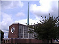
8
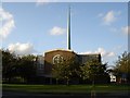
Our Lady of Fatima
Catholic church built 1958-60 was closed for 4 years to reburbish the pre-stressed concrete structure. The architect was Gerald Goalen.
Image: © Roger McLachlan
Taken: 21 Oct 2006
0.13 miles
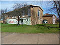
10
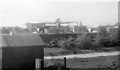
Burnt Mill Comprehensive School, 1971
Taken from a bus on First Avenue.
I'm fairly sure this is correctly identified, if you know different, please let me know.
Image: © Penny Mayes
Taken: 1 Jan 1971
0.15 miles