IMAGES TAKEN NEAR TO
CM20 2TE
Introduction
This page details the photographs taken nearby to CM20 2TE by members of the Geograph project.
The Geograph project started in 2005 with the aim of publishing, organising and preserving representative images for every square kilometre of Great Britain, Ireland and the Isle of Man.

There are currently over 7.5m images from over14,400 individuals and you can help contribute to the project by visiting https://www.geograph.org.uk
Image Map
Images are licensed for reuse under creativecommons.org/licenses/by-sa/2.0
Notes
- Clicking on the map will re-center to the selected point.
- The higher the marker number, the further away the image location is from the centre of the postcode.
Image Listing (4 Images Found)
Images are licensed for reuse under creativecommons.org/licenses/by-sa/2.0
Image
Details
Distance
1
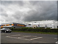
Industrial buildings on Edinburgh Way, Harlow
Image: © David Howard
Taken: 13 Jun 2013
0.03 miles
2
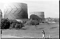
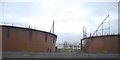
Temple Fields, Harlow, 1971
With the now disused gas holders http://www.geograph.org.uk/photo/3546939 seen from a bus.
Image: © Penny Mayes
Taken: Unknown
0.12 miles
4
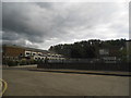
South Road from the junction of Central Road, Harlow
Image: © David Howard
Taken: 13 Jun 2013
0.24 miles