IMAGES TAKEN NEAR TO
Stackfield, HARLOW, CM20 2LB
Introduction
This page details the photographs taken nearby to Stackfield, CM20 2LB by members of the Geograph project.
The Geograph project started in 2005 with the aim of publishing, organising and preserving representative images for every square kilometre of Great Britain, Ireland and the Isle of Man.

There are currently over 7.5m images from over14,400 individuals and you can help contribute to the project by visiting https://www.geograph.org.uk
Image Map
Images are licensed for reuse under creativecommons.org/licenses/by-sa/2.0
Notes
- Clicking on the map will re-center to the selected point.
- The higher the marker number, the further away the image location is from the centre of the postcode.
Image Listing (15 Images Found)
Images are licensed for reuse under creativecommons.org/licenses/by-sa/2.0
Image
Details
Distance
1
Milepost
This is one of 1000 mileposts funded by the Royal Bank of Scotland to mark the creation of the National Cycle Network. This milepost is on National Cycle Route 1, which runs from Dover to London and then up the east coast to Edinburgh and on to John o'Groats, Orkney and Shetland. Post markings read as follows: South - Harlow Museum ½ Mile, East - Harlow Town Centre 1½ Miles & Hertford 14 Miles, North - Templefields, West - Old Harlow 1½ Miles & Chelmsford 21 Miles. https://www.sustrans.org.uk
Image: © David Malt
Taken: 30 Jul 2006
0.12 miles
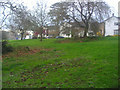
3
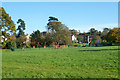
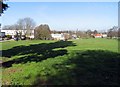
Play area, Mark Hall Park, Harlow
An unfenced area more in the nature of a green or common than a park.
Image: © Robin Webster
Taken: 4 Nov 2014
0.17 miles
4
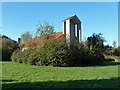
RCCG Lord's Vine, Harlow
Part of the Redeemed Christian Church of God. A rear view, the hedge separating it from Mark Hall Park is rather overgrown.
Image: © Robin Webster
Taken: 4 Nov 2014
0.17 miles
5
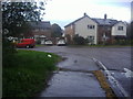
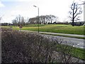
Muskham Road, Harlow
Mark Hall Park is on the left.
Image: © David Howard
Taken: 12 Apr 2012
0.17 miles
7
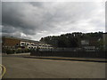
South Road from the junction of Central Road, Harlow
Image: © David Howard
Taken: 13 Jun 2013
0.19 miles
8
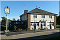
The White Admiral, Harlow
One of the new town pubs, which were all named after species of moth or butterfly. This side of the inn sign does not give this away, it shows a naval sort of admiral. The actual butterfly is depicted on the other side.
Image: © Robin Webster
Taken: 4 Nov 2014
0.19 miles