IMAGES TAKEN NEAR TO
The Wintons, Rivermill, HARLOW, CM20 1NR
Introduction
This page details the photographs taken nearby to The Wintons, Rivermill, CM20 1NR by members of the Geograph project.
The Geograph project started in 2005 with the aim of publishing, organising and preserving representative images for every square kilometre of Great Britain, Ireland and the Isle of Man.

There are currently over 7.5m images from over14,400 individuals and you can help contribute to the project by visiting https://www.geograph.org.uk
Image Map
Images are licensed for reuse under creativecommons.org/licenses/by-sa/2.0
Notes
- Clicking on the map will re-center to the selected point.
- The higher the marker number, the further away the image location is from the centre of the postcode.
Image Listing (20 Images Found)
Images are licensed for reuse under creativecommons.org/licenses/by-sa/2.0
Image
Details
Distance
1
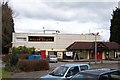
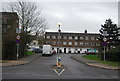
The Willow Beauty, Harlow
All of the "new town" pubs in Harlow are named after moths or butterflies. The Willow Beauty (a moth) is a popular pub adjacent to a cricket ground and the sports centre.
Image: © Geoff Barber
Taken: 22 Mar 2006
0.12 miles
6
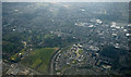
Harlow from the air
Housing around the roundabout on the site of Harlow FC's ground Image Harlow Town Park is in the left foreground.
Image: © Thomas Nugent
Taken: 16 Mar 2016
0.17 miles
9
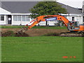
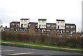
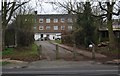
Before they knocked it down
Harlow town football club as was. Now a housing estate (Fifth Avenue).
Image: © Glen Woolmore
Taken: 15 Sep 2006
0.18 miles
10
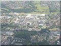
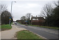
Harlow Centre
Looking southeast on the approach to London (Stansted) Airport.
Image: © M J Richardson
Taken: 12 Jul 2017
0.18 miles