IMAGES TAKEN NEAR TO
Hodings Road, HARLOW, CM20 1AT
Introduction
This page details the photographs taken nearby to Hodings Road, CM20 1AT by members of the Geograph project.
The Geograph project started in 2005 with the aim of publishing, organising and preserving representative images for every square kilometre of Great Britain, Ireland and the Isle of Man.

There are currently over 7.5m images from over14,400 individuals and you can help contribute to the project by visiting https://www.geograph.org.uk
Image Map
Images are licensed for reuse under creativecommons.org/licenses/by-sa/2.0
Notes
- Clicking on the map will re-center to the selected point.
- The higher the marker number, the further away the image location is from the centre of the postcode.
Image Listing (8 Images Found)
Images are licensed for reuse under creativecommons.org/licenses/by-sa/2.0
Image
Details
Distance
5
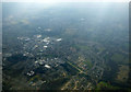
Harlow from the air
Looking over the Princess Alexandra Hospital towards the town centre.
Image: © Thomas Nugent
Taken: 16 Mar 2016
0.19 miles
6
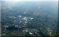
Harlow from the air
Looking over the Princess Alexandra Hospital towards the town centre.
Image: © Thomas Nugent
Taken: 16 Mar 2016
0.19 miles
7
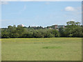
View towards Harlow
A view across the flat Stort Valley towards the low hill on which Harlow is built. The rightmost of the two large buildings in the distance appears to be on Spring Hills.
Image: © Stephen Craven
Taken: 22 May 2011
0.19 miles