IMAGES TAKEN NEAR TO
Wellesley, HARLOW, CM19 5QX
Introduction
This page details the photographs taken nearby to Wellesley, CM19 5QX by members of the Geograph project.
The Geograph project started in 2005 with the aim of publishing, organising and preserving representative images for every square kilometre of Great Britain, Ireland and the Isle of Man.

There are currently over 7.5m images from over14,400 individuals and you can help contribute to the project by visiting https://www.geograph.org.uk
Image Map (Loading...)


Getting Data...Please wait
Leaflet Map data © OpenStreetMap
Images are licensed for reuse under creativecommons.org/licenses/by-sa/2.0
Notes
- Clicking on the map will re-center to the selected point.
- The higher the marker number, the further away the image location is from the centre of the postcode.
Image Listing (5 Images Found)
Images are licensed for reuse under creativecommons.org/licenses/by-sa/2.0
Image
Details
Distance
1
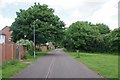
Cycleway in Sumners
Looking towards Burnett's Wood
Image: © Glyn Baker
Taken: 3 Jun 2017
0.12 miles
2
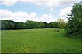
Open Space in Sumners
There is a surfaced path that runs around the perimeter of this public open space.
Image: © Glyn Baker
Taken: 3 Jun 2017
0.12 miles
3
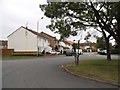
Roundabout on Parsloe Road, Jack's Hatch
Image: © David Howard
Taken: 20 Aug 2017
0.14 miles
4
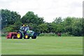
Rec By Parsloe Road
The grass was getting the full treatment today.
Image: © Glyn Baker
Taken: 3 Jun 2017
0.18 miles
5
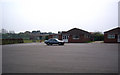
Risden Training Centre
The Risden Training Centre and Sports Club in Parsloe Road.
Image: © Lynda Poulter
Taken: 12 Apr 2007
0.21 miles