IMAGES TAKEN NEAR TO
Tinkers Lane, HARLOW, CM19 5LH
Introduction
This page details the photographs taken nearby to Tinkers Lane, CM19 5LH by members of the Geograph project.
The Geograph project started in 2005 with the aim of publishing, organising and preserving representative images for every square kilometre of Great Britain, Ireland and the Isle of Man.

There are currently over 7.5m images from over14,400 individuals and you can help contribute to the project by visiting https://www.geograph.org.uk
Image Map (Loading...)


Getting Data...Please wait
Leaflet Map data © OpenStreetMap
Images are licensed for reuse under creativecommons.org/licenses/by-sa/2.0
Notes
- Clicking on the map will re-center to the selected point.
- The higher the marker number, the further away the image location is from the centre of the postcode.
Image Listing (17 Images Found)
Images are licensed for reuse under creativecommons.org/licenses/by-sa/2.0
Image
Details
Distance


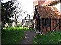
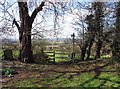
5
View from All Saints, Nazeing churchyard, Essex
Image: © John Salmon
Taken: 14 Mar 2007
0.19 miles
6
View from All Saints, Nazeing churchyard, Essex
Image: © John Salmon
Taken: 14 Mar 2007
0.20 miles
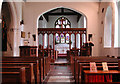
8

All Saints, Nazeing, Essex - Window
Depicting St Francis. Window by Peter Cormack.
Image: © John Salmon
Taken: 14 Mar 2007
0.21 miles
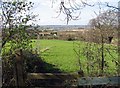
9

View north from Nazeing churchyard
Towards Roydon Hamlet.
Image: © Robin Webster
Taken: 13 Mar 2014
0.21 miles