IMAGES TAKEN NEAR TO
Dobbs Weir Road, HARLOW, CM19 5JX
Introduction
This page details the photographs taken nearby to Dobbs Weir Road, CM19 5JX by members of the Geograph project.
The Geograph project started in 2005 with the aim of publishing, organising and preserving representative images for every square kilometre of Great Britain, Ireland and the Isle of Man.

There are currently over 7.5m images from over14,400 individuals and you can help contribute to the project by visiting https://www.geograph.org.uk
Image Map (Loading...)


Getting Data...Please wait
Leaflet Map data © OpenStreetMap
Images are licensed for reuse under creativecommons.org/licenses/by-sa/2.0
Notes
- Clicking on the map will re-center to the selected point.
- The higher the marker number, the further away the image location is from the centre of the postcode.
Image Listing (12 Images Found)
Images are licensed for reuse under creativecommons.org/licenses/by-sa/2.0
Image
Details
Distance
1
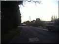
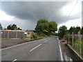
Sedge Green
This is the name of the road and the village, nearly all taken up with nurseries with houses in between.
Image: © David Howard
Taken: 7 Feb 2012
0.07 miles
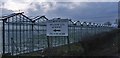
2
Lowershot Nursery, Sedge Green
One of several plant nurseries in the area, many of which appear to have Italian owners. This one is operated by A.M.Martorana.
Image: © Stephen Craven
Taken: 15 Aug 2009
0.09 miles
3
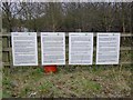
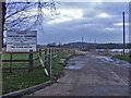
Signs of the times: multi-lingual notices at Netherhall Fishery
These are Environment Agency notices reminding anglers of the need to hold a rod licence. The foreign languages are Rumanian, Polish and Latvian.
For a wider view of the entrance to the fishery, see Image
Image: © Stefan Czapski
Taken: 3 Mar 2013
0.11 miles
4
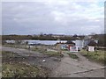
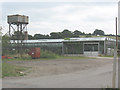
Netherhall Fishery, Dobbs Weir Road
Flooded gravel workings, now managed as a fishery. Quarrying here was relatively recent - an OS 1:50K sheet published in 1974 shows no excavations.
I was interested to find multi-lingual notices posted near the gate - the Environment Agency reminding anglers of the need to obtain a rod licence.
Image: © Stefan Czapski
Taken: 3 Mar 2013
0.12 miles
5
Netherhall Fishery, Dobbs Weir Road
Netherhall Fishery in Dobbs Weir Road is opposite the Meadow Lea Nursery
Image: © Christine Matthews
Taken: 15 Jan 2006
0.13 miles
7
Low Hill Nurseries, Sedge Green
One of many plant nurseries in the Nazeing area. The map shows a public footpath running through this yard, though there was no signpost for it on the ground.
Image: © Stephen Craven
Taken: 15 Aug 2009
0.16 miles
8
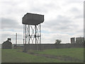
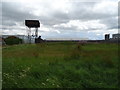
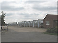
Water tower at Sedge Green
Each of the several nurseries in the area has its own water tower(s) to provide adequate pressure for watering the plants in the greenhouses.
Image: © Stephen Craven
Taken: 15 Aug 2009
0.16 miles
9
Meadow Lea Nursery, Dobbs Weir Road
Meadow Lea Nursery, south side of Dobbs Weir Road, opposite Netherhall Fishery
Image: © Christine Matthews
Taken: 15 Jan 2006
0.16 miles