IMAGES TAKEN NEAR TO
Low Hill Road, HARLOW, CM19 5JW
Introduction
This page details the photographs taken nearby to Low Hill Road, CM19 5JW by members of the Geograph project.
The Geograph project started in 2005 with the aim of publishing, organising and preserving representative images for every square kilometre of Great Britain, Ireland and the Isle of Man.

There are currently over 7.5m images from over14,400 individuals and you can help contribute to the project by visiting https://www.geograph.org.uk
Image Map
Images are licensed for reuse under creativecommons.org/licenses/by-sa/2.0
Notes
- Clicking on the map will re-center to the selected point.
- The higher the marker number, the further away the image location is from the centre of the postcode.
Image Listing (10 Images Found)
Images are licensed for reuse under creativecommons.org/licenses/by-sa/2.0
Image
Details
Distance
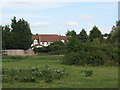
2
Ploughed field near Downe Hall, Roydon
Image: © Stephen Craven
Taken: 15 Aug 2009
0.15 miles
3
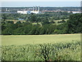
Another distant view of Rye House power station
Image: © Peter S
Taken: 4 Jul 2019
0.15 miles
4
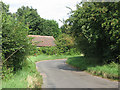
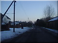
Bend on Low Hill Road
The unwary motorist or cyclist may approach this bend after a leng drive or ride on the flat roads of the Lee Valley and be unprepared for the 14% gradient that confronts them - it is only signed at the top Image
Image: © Stephen Craven
Taken: 15 Aug 2009
0.15 miles
5
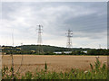
Pylons east of Low Hill Road
Heading east from a substation at Rye House.
Image: © Robin Webster
Taken: 17 Aug 2015
0.16 miles
6
Netherhall Farm with remains of Netherhall, Roydon, Essex
Netherhall Farm with the remains of Netherhall to the right
Image: © Christine Matthews
Taken: 15 Jan 2006
0.19 miles
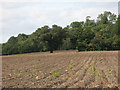
7
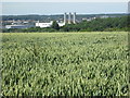
Rye House power station appearing beyond a wheat field
Image: © Peter S
Taken: 4 Jul 2019
0.21 miles
8
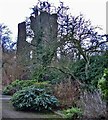
Remains of Netherhall, Roydon, Essex
Ruined gatehouse, to fortified house now mostly demolished. Mid C15 in red brick, with diapering in white brick and flared headers. 2 semi-octagonal towers with gateway between. 3 storeys. Trefoiled corbelled parapets. To the rear of the former right hand tower, is a further semi-octagonal projection rising to full height of the building, and behind this a staircase tower. Outer face of left hand tower has cruciform loops to ground floor, and windows with four centred heads and square labels. Right hand side has square headed windows, and is surmounted by 2 chimney shafts of spirally moulded brick with moulded caps and bases. Between the 2 towers is the original outer arch of the gateway, with moulded stone jambs and 4 centred arch in a square head. Above are the remains of a square headed window of stone. Part of the curtain wall to the right survives, but on remaining sides is represented by foundations only. Lower part of north west angle tower survives, with cruciform loops in each face. Foundation mounds of domestic buildings are traceable within the walls. Internally, the left hand side of the gatehouse, 3 rooms survive at ground floor, 2 with barrel vaults. The original circular brick newel stair has sunk and moulded brick handrail. Rectangular moat with original brick revetments to outer bank.
Image: © Christine Matthews
Taken: 15 Jan 2006
0.22 miles
9
Netherhall Road, Roydon
The nurseries are next to the house and surrounding it.
Image: © David Howard
Taken: 7 Feb 2012
0.22 miles
10
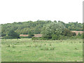
The Grove
The Grove is the name of this woodland on the slopes of the Lee/Lea Valley.
Image: © Stephen Craven
Taken: 15 Aug 2009
0.24 miles