IMAGES TAKEN NEAR TO
Elizabeth Way, HARLOW, CM19 5FF
Introduction
This page details the photographs taken nearby to Elizabeth Way, CM19 5FF by members of the Geograph project.
The Geograph project started in 2005 with the aim of publishing, organising and preserving representative images for every square kilometre of Great Britain, Ireland and the Isle of Man.

There are currently over 7.5m images from over14,400 individuals and you can help contribute to the project by visiting https://www.geograph.org.uk
Image Map (Loading...)


Getting Data...Please wait
Leaflet Map data © OpenStreetMap
Images are licensed for reuse under creativecommons.org/licenses/by-sa/2.0
Notes
- Clicking on the map will re-center to the selected point.
- The higher the marker number, the further away the image location is from the centre of the postcode.
Image Listing (4 Images Found)
Images are licensed for reuse under creativecommons.org/licenses/by-sa/2.0
Image
Details
Distance
1
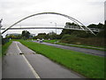
Harlow: A1169 Third Avenue
This is an elegant footbridge that links the New Frontiers Science Park with the GlaxoSmithKline site over the A1169 road.
Image: © Nigel Cox
Taken: 25 Oct 2006
0.06 miles
2
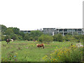
Horse paddock on the edge of Harlow
Several horses and ponies are kept on this patch of what would otherwise be described as waste ground.
Image: © Stephen Craven
Taken: 15 Aug 2009
0.06 miles
3
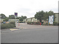
Ash Industrial Estate, Harlow
A small group of light industrial units accessed from the road called Flex Meadow.
Image: © Stephen Craven
Taken: 15 Aug 2009
0.07 miles
4
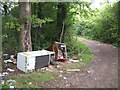
Fly tipping on Old House Lane
One of several examples of fly tipping on this bridleway, a consequence of it being physically accessible to vehicles.
Image: © Stephen Craven
Taken: 15 Aug 2009
0.21 miles