IMAGES TAKEN NEAR TO
High Street, HARLOW, CM19 5EA
Introduction
This page details the photographs taken nearby to High Street, CM19 5EA by members of the Geograph project.
The Geograph project started in 2005 with the aim of publishing, organising and preserving representative images for every square kilometre of Great Britain, Ireland and the Isle of Man.

There are currently over 7.5m images from over14,400 individuals and you can help contribute to the project by visiting https://www.geograph.org.uk
Image Map (Loading...)


Getting Data...Please wait
Leaflet Map data © OpenStreetMap
Images are licensed for reuse under creativecommons.org/licenses/by-sa/2.0
Notes
- Clicking on the map will re-center to the selected point.
- The higher the marker number, the further away the image location is from the centre of the postcode.
Image Listing (55 Images Found)
Images are licensed for reuse under creativecommons.org/licenses/by-sa/2.0
Image
Details
Distance
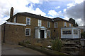
3
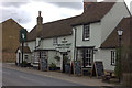
The White Hart, Roydon
A grade II listed building, 15th century with later alterations.
Image: © Robin Webster
Taken: 13 Mar 2014
0.02 miles
6
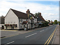
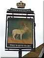
The White Hart, Roydon High Street
One of four pubs on the high street, though one of them had already become an Indian restaurant by 2009. See Image for another.
Image: © Stephen Craven
Taken: 15 Aug 2009
0.02 miles

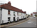
9
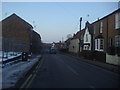
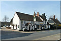
High Street Roydon
The gap on the left was the Spur petrol station, another casualty of the economy apparently.
Image: © David Howard
Taken: 7 Feb 2012
0.04 miles
10
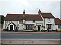
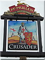
The Bengal Lancers, Roydon
Formerly The White Horse (The Top House)
Image: © Ian S
Taken: 29 May 2013
0.05 miles