IMAGES TAKEN NEAR TO
Old House Lane, HARLOW, CM19 5DN
Introduction
This page details the photographs taken nearby to Old House Lane, CM19 5DN by members of the Geograph project.
The Geograph project started in 2005 with the aim of publishing, organising and preserving representative images for every square kilometre of Great Britain, Ireland and the Isle of Man.

There are currently over 7.5m images from over14,400 individuals and you can help contribute to the project by visiting https://www.geograph.org.uk
Image Map (Loading...)


Getting Data...Please wait
Leaflet Map data © OpenStreetMap
Images are licensed for reuse under creativecommons.org/licenses/by-sa/2.0
Notes
- Clicking on the map will re-center to the selected point.
- The higher the marker number, the further away the image location is from the centre of the postcode.
Image Listing (8 Images Found)
Images are licensed for reuse under creativecommons.org/licenses/by-sa/2.0
Image
Details
Distance
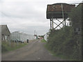
2
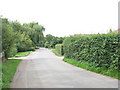
Old House Lane near Halls Green
A residential street leading to some commercial nurseries Image / Image, Old House Lane is a 'no through road' to motor traffic but continues as a bridleway Image
Image: © Stephen Craven
Taken: 15 Aug 2009
0.02 miles
4
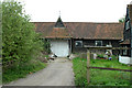
Nurseries off Old House Lane
One of many nurseries in this area.
Image: © Stephen Craven
Taken: 15 Aug 2009
0.11 miles
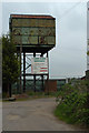
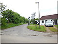
5
Morreale's Nursery, Old House Lane
The last (most northerly) of the many nurseries in the Nazeing area.
Image: © Stephen Craven
Taken: 15 Aug 2009
0.12 miles
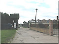
6
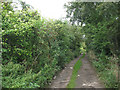
Old House Lane (bridleway)
The lane ceases to be surfaced after the last of the nurseries Image and continues as a bridleway towards Harlow.
Image: © Stephen Craven
Taken: 15 Aug 2009
0.16 miles
8
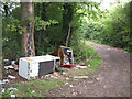
Fly tipping on Old House Lane
One of several examples of fly tipping on this bridleway, a consequence of it being physically accessible to vehicles.
Image: © Stephen Craven
Taken: 15 Aug 2009
0.24 miles