IMAGES TAKEN NEAR TO
Horsecroft Road, HARLOW, CM19 5BP
Introduction
This page details the photographs taken nearby to Horsecroft Road, CM19 5BP by members of the Geograph project.
The Geograph project started in 2005 with the aim of publishing, organising and preserving representative images for every square kilometre of Great Britain, Ireland and the Isle of Man.

There are currently over 7.5m images from over14,400 individuals and you can help contribute to the project by visiting https://www.geograph.org.uk
Image Map (Loading...)


Getting Data...Please wait
Leaflet Map data © OpenStreetMap
Images are licensed for reuse under creativecommons.org/licenses/by-sa/2.0
Notes
- Clicking on the map will re-center to the selected point.
- The higher the marker number, the further away the image location is from the centre of the postcode.
Image Listing (4 Images Found)
Images are licensed for reuse under creativecommons.org/licenses/by-sa/2.0
Image
Details
Distance
1
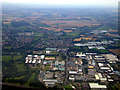
Pinnacles Industrial Estate from the air
The Glaxo Smith Kline campus Image is prominent to the left of Elizabeth Way which runs vertically through the lower half of the photo.
Image: © Thomas Nugent
Taken: 29 Jul 2011
0.04 miles
2
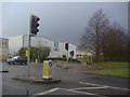
Junction of Fourth Way and Elizabeth Way, Harlow
On the Pinnacles industrial estate
Image: © David Howard
Taken: 12 Apr 2012
0.24 miles
3
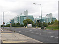
Glaxo Smith Kline research unit, Harlow
The site on Elizabeth Way was shown as vacant on the online Landranger map at the time of submission so the buildings must have been built recently (c. 2005-2009). The GSK website declares it to be a research & development facility.
Image: © Stephen Craven
Taken: 15 Aug 2009
0.25 miles
4
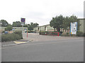
Ash Industrial Estate, Harlow
A small group of light industrial units accessed from the road called Flex Meadow.
Image: © Stephen Craven
Taken: 15 Aug 2009
0.25 miles