IMAGES TAKEN NEAR TO
Parndon Wood Road, HARLOW, CM19 4SE
Introduction
This page details the photographs taken nearby to Parndon Wood Road, CM19 4SE by members of the Geograph project.
The Geograph project started in 2005 with the aim of publishing, organising and preserving representative images for every square kilometre of Great Britain, Ireland and the Isle of Man.

There are currently over 7.5m images from over14,400 individuals and you can help contribute to the project by visiting https://www.geograph.org.uk
Image Map
Images are licensed for reuse under creativecommons.org/licenses/by-sa/2.0
Notes
- Clicking on the map will re-center to the selected point.
- The higher the marker number, the further away the image location is from the centre of the postcode.
Image Listing (8 Images Found)
Images are licensed for reuse under creativecommons.org/licenses/by-sa/2.0
Image
Details
Distance
1
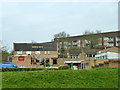
The Drinker Moth, Harlow
A 'new town' pub, one of a series named with a natural history theme, although none quite as appropriate as this.
Image: © Robin Webster
Taken: 20 Mar 2014
0.08 miles
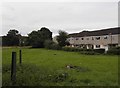
3
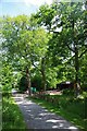
Parndon Woods Nature Reserve
Parndon Woods Nature Reserve is managed by Harlow Council since 1968 http://www.wildessex.net/sites/Parndon%20Woods%20and%20Common.htm
Image: © Glyn Baker
Taken: 26 May 2017
0.14 miles
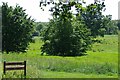
4
Beetle Food In Harlow's Hay Meadow
Standing timber rots differently and so provides more diverse habitats than fallen wood alone, so modern practice is to leave dead trees standing if they do not present a danger to the public.
Image: © Glyn Baker
Taken: 26 May 2017
0.15 miles
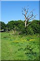
5
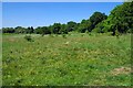
Harlow's Hay Meadow
Well that's what is says on the Image
Image: © Glyn Baker
Taken: 26 May 2017
0.17 miles
6
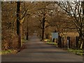
The entrance to Parndon Wood Crematorium & Cemetery
Image: © Robert Edwards
Taken: 12 Mar 2008
0.19 miles
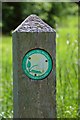
8
Parndon Wood Visitor Centre
Image http://www.wildessex.net/sites/Parndon%20Woods%20and%20Common.htm surrounds the local cemetery.
Image: © Glyn Baker
Taken: 3 Jun 2017
0.22 miles