IMAGES TAKEN NEAR TO
Brockles Mead, HARLOW, CM19 4QD
Introduction
This page details the photographs taken nearby to Brockles Mead, CM19 4QD by members of the Geograph project.
The Geograph project started in 2005 with the aim of publishing, organising and preserving representative images for every square kilometre of Great Britain, Ireland and the Isle of Man.

There are currently over 7.5m images from over14,400 individuals and you can help contribute to the project by visiting https://www.geograph.org.uk
Image Map (Loading...)


Getting Data...Please wait
Leaflet Map data © OpenStreetMap
Images are licensed for reuse under creativecommons.org/licenses/by-sa/2.0
Notes
- Clicking on the map will re-center to the selected point.
- The higher the marker number, the further away the image location is from the centre of the postcode.
Image Listing (7 Images Found)
Images are licensed for reuse under creativecommons.org/licenses/by-sa/2.0
Image
Details
Distance
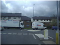
1
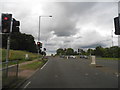
Third Avenue at the junction of Abercrombie Way
Image: © David Howard
Taken: 13 Jun 2013
0.14 miles
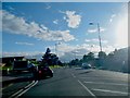
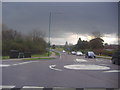
3
Roundabout on Southern Way, Harlow
At the junction with Ployters Road
Image: © David Howard
Taken: 23 Oct 2015
0.14 miles
4
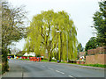
Weeping willows, Harlow
By Paringdon Road.
Image: © Robin Webster
Taken: 20 Mar 2014
0.16 miles
5
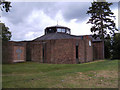
St James with St Luke Harlow Essex
Situated in Perry Road.
Image: © Peter Stack
Taken: 7 Jun 2009
0.19 miles
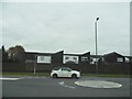
6
Mini roundabout on Southern Way and Kingsmoor Road
Image: © David Howard
Taken: 12 Apr 2012
0.24 miles
7
Junction of Partridge Road and Southern Way
Image: © David Howard
Taken: 12 Apr 2012
0.25 miles