IMAGES TAKEN NEAR TO
Fir Park, HARLOW, CM19 4JX
Introduction
This page details the photographs taken nearby to Fir Park, CM19 4JX by members of the Geograph project.
The Geograph project started in 2005 with the aim of publishing, organising and preserving representative images for every square kilometre of Great Britain, Ireland and the Isle of Man.

There are currently over 7.5m images from over14,400 individuals and you can help contribute to the project by visiting https://www.geograph.org.uk
Image Map
Images are licensed for reuse under creativecommons.org/licenses/by-sa/2.0
Notes
- Clicking on the map will re-center to the selected point.
- The higher the marker number, the further away the image location is from the centre of the postcode.
Image Listing (6 Images Found)
Images are licensed for reuse under creativecommons.org/licenses/by-sa/2.0
Image
Details
Distance
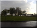
1
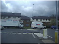
Junction of Partridge Road and Southern Way
Image: © David Howard
Taken: 12 Apr 2012
0.15 miles
2
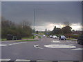
Mini roundabout on Southern Way and Kingsmoor Road
Image: © David Howard
Taken: 12 Apr 2012
0.16 miles
3
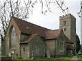
Church of St. Mary the Virgin, Great Parndon, Harlow, Essex
Not far from 'The Cock' Public House
Image: © Patrick Lee
Taken: 28 Mar 2005
0.19 miles
4

'The Cock' Public House, Great Parndon, Harlow, Essex
Image: © Patrick Lee
Taken: 13 Feb 2005
0.19 miles
5
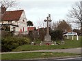
The War Memorial at Cocks Green, Great Parndon
Image: © Robert Edwards
Taken: 17 Mar 2008
0.20 miles
6
Roundabout on Southern Way and Katherine Way
Image: © David Howard
Taken: 12 Apr 2012
0.24 miles