IMAGES TAKEN NEAR TO
Jerounds, HARLOW, CM19 4HE
Introduction
This page details the photographs taken nearby to Jerounds, CM19 4HE by members of the Geograph project.
The Geograph project started in 2005 with the aim of publishing, organising and preserving representative images for every square kilometre of Great Britain, Ireland and the Isle of Man.

There are currently over 7.5m images from over14,400 individuals and you can help contribute to the project by visiting https://www.geograph.org.uk
Image Map
Images are licensed for reuse under creativecommons.org/licenses/by-sa/2.0
Notes
- Clicking on the map will re-center to the selected point.
- The higher the marker number, the further away the image location is from the centre of the postcode.
Image Listing (12 Images Found)
Images are licensed for reuse under creativecommons.org/licenses/by-sa/2.0
Image
Details
Distance
3
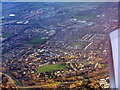
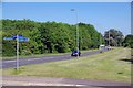
Great Parndon from the northwest
The western outskirts of Harlow. The crescent shaped block of buildings at top left is the Bishopsfield Estate Image, http://www.eafa.org.uk/catalogue/253 .
Image: © M J Richardson
Taken: 6 Feb 2018
0.17 miles
4
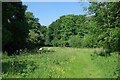
Path Through Hawkenbury Meadow
Image: © Glyn Baker
Taken: 26 May 2017
0.20 miles
5
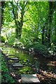
Stepping Stones to Rectory Road
Image: © Glyn Baker
Taken: 26 May 2017
0.21 miles
6
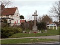
The War Memorial at Cocks Green, Great Parndon
Image: © Robert Edwards
Taken: 17 Mar 2008
0.22 miles
7
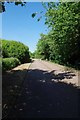
Cycleway to Hare St
Technically this is a public footpath but the council have put up what I consider is a Image to indicate cycling is permitted.
Image: © Glyn Baker
Taken: 26 May 2017
0.22 miles
8
Cycle Routes by the A1025
I think the finger post is a Image
Image: © Glyn Baker
Taken: 26 May 2017
0.23 miles
9
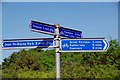
Very Silly Sign
What planet are the traffic planners on? How is it possible to say how long it will take to get to a destination unless you mandate a cycling speed? These signs take no account of the cyclist being a very aged great granddad on a "Brompton" or a Bradly Wiggins emulator in dayglow lycra. I suspect the planners couldn't get an EU grant for the cycle paths if the distances were in miles (N.B. I have my GPS set to km).
Image: © Glyn Baker
Taken: 26 May 2017
0.23 miles