IMAGES TAKEN NEAR TO
Northbrooks, HARLOW, CM19 4DE
Introduction
This page details the photographs taken nearby to Northbrooks, CM19 4DE by members of the Geograph project.
The Geograph project started in 2005 with the aim of publishing, organising and preserving representative images for every square kilometre of Great Britain, Ireland and the Isle of Man.

There are currently over 7.5m images from over14,400 individuals and you can help contribute to the project by visiting https://www.geograph.org.uk
Image Map
Images are licensed for reuse under creativecommons.org/licenses/by-sa/2.0
Notes
- Clicking on the map will re-center to the selected point.
- The higher the marker number, the further away the image location is from the centre of the postcode.
Image Listing (3 Images Found)
Images are licensed for reuse under creativecommons.org/licenses/by-sa/2.0
Image
Details
Distance
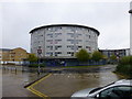
1
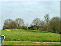
Greensward by Abercrombie Way
Part of a ribbon of green between Third Avenue and the Todd Brook.
Image: © Robin Webster
Taken: 20 Mar 2014
0.22 miles
2
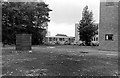
Harlow Technical College, College Square
Viewed from the large, disused cinder car park also seen here http://www.geograph.org.uk/photo/2804728 .
The building on the right is part of St Paul's church (on the left in this shot http://www.geograph.org.uk/photo/2804759 ), cars are parked in College Square and most of the other buildings in view are part of the College and are now gone.
Image: © Penny Mayes
Taken: 1 Jan 1971
0.24 miles