IMAGES TAKEN NEAR TO
Berecroft, HARLOW, CM18 7SD
Introduction
This page details the photographs taken nearby to Berecroft, CM18 7SD by members of the Geograph project.
The Geograph project started in 2005 with the aim of publishing, organising and preserving representative images for every square kilometre of Great Britain, Ireland and the Isle of Man.

There are currently over 7.5m images from over14,400 individuals and you can help contribute to the project by visiting https://www.geograph.org.uk
Image Map
Images are licensed for reuse under creativecommons.org/licenses/by-sa/2.0
Notes
- Clicking on the map will re-center to the selected point.
- The higher the marker number, the further away the image location is from the centre of the postcode.
Image Listing (4 Images Found)
Images are licensed for reuse under creativecommons.org/licenses/by-sa/2.0
Image
Details
Distance
1
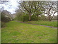
Footpath along Rye Hill Road
This is the southern perimeter of Harlow new town and Rye Hill Road is the only minor road linking the town to the south.
Image: © David Howard
Taken: 12 Apr 2012
0.11 miles
2
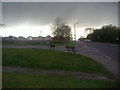
Junction of Rye Hill Road and Paringdon Road
Image: © David Howard
Taken: 12 Apr 2012
0.11 miles
4
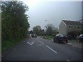
Commonside Road, Harlow
This road restriction is a typical example (in my opinion anyhow) of how making roads harder to drive along actually makes them a lot more dangerous than they were before. You only need one person to get confused or impatient and you have a head on accident.
Image: © David Howard
Taken: 12 Apr 2012
0.25 miles