IMAGES TAKEN NEAR TO
Peterswood, HARLOW, CM18 7RJ
Introduction
This page details the photographs taken nearby to Peterswood, CM18 7RJ by members of the Geograph project.
The Geograph project started in 2005 with the aim of publishing, organising and preserving representative images for every square kilometre of Great Britain, Ireland and the Isle of Man.

There are currently over 7.5m images from over14,400 individuals and you can help contribute to the project by visiting https://www.geograph.org.uk
Image Map
Images are licensed for reuse under creativecommons.org/licenses/by-sa/2.0
Notes
- Clicking on the map will re-center to the selected point.
- The higher the marker number, the further away the image location is from the centre of the postcode.
Image Listing (2 Images Found)
Images are licensed for reuse under creativecommons.org/licenses/by-sa/2.0
Image
Details
Distance
1
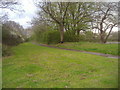
Footpath along Rye Hill Road
This is the southern perimeter of Harlow new town and Rye Hill Road is the only minor road linking the town to the south.
Image: © David Howard
Taken: 12 Apr 2012
0.20 miles
2
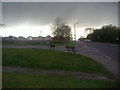
Junction of Rye Hill Road and Paringdon Road
Image: © David Howard
Taken: 12 Apr 2012
0.21 miles