IMAGES TAKEN NEAR TO
Hilly Field, HARLOW, CM18 7HU
Introduction
This page details the photographs taken nearby to Hilly Field, CM18 7HU by members of the Geograph project.
The Geograph project started in 2005 with the aim of publishing, organising and preserving representative images for every square kilometre of Great Britain, Ireland and the Isle of Man.

There are currently over 7.5m images from over14,400 individuals and you can help contribute to the project by visiting https://www.geograph.org.uk
Image Map
Images are licensed for reuse under creativecommons.org/licenses/by-sa/2.0
Notes
- Clicking on the map will re-center to the selected point.
- The higher the marker number, the further away the image location is from the centre of the postcode.
Image Listing (6 Images Found)
Images are licensed for reuse under creativecommons.org/licenses/by-sa/2.0
Image
Details
Distance
1
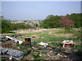
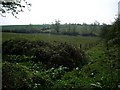
What a View
Or is it? Possibly not the best view in The Area.
Image: © Lynda Poulter
Taken: 14 Apr 2007
0.15 miles
2
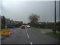
Commonside Road, Harlow
Tysea Road is on the left and currently the route back to the main road until the works are finished.
Image: © David Howard
Taken: 12 Apr 2012
0.19 miles
3
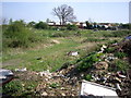
Litter
The only area of grassland here that isn't strewn with litter.
Image: © Lynda Poulter
Taken: 14 Apr 2007
0.20 miles
4
Tysea Road at the corner of Commonside Road
Image: © David Howard
Taken: 12 Apr 2012
0.21 miles
6
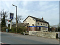
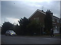
The Chequers (closed)
On Commonside Road, Harlow. The estate agent's sign says 'Sold'.
Image: © Robin Webster
Taken: 20 Mar 2014
0.24 miles