IMAGES TAKEN NEAR TO
Radburn Close, HARLOW, CM18 7EG
Introduction
This page details the photographs taken nearby to Radburn Close, CM18 7EG by members of the Geograph project.
The Geograph project started in 2005 with the aim of publishing, organising and preserving representative images for every square kilometre of Great Britain, Ireland and the Isle of Man.

There are currently over 7.5m images from over14,400 individuals and you can help contribute to the project by visiting https://www.geograph.org.uk
Image Map (Loading...)


Getting Data...Please wait
Leaflet Map data © OpenStreetMap
Images are licensed for reuse under creativecommons.org/licenses/by-sa/2.0
Notes
- Clicking on the map will re-center to the selected point.
- The higher the marker number, the further away the image location is from the centre of the postcode.
Image Listing (7 Images Found)
Images are licensed for reuse under creativecommons.org/licenses/by-sa/2.0
Image
Details
Distance
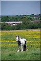
3
Horses on Latton Common
An area of public open space, with many tethered horses.
Image: © Robin Webster
Taken: 17 Aug 2015
0.14 miles
4
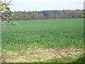
Looking towards Mark Bushes
The boundary line of Mark Bushes in the distance. A crop field in the foreground.
Image: © Lynda Poulter
Taken: 14 Apr 2007
0.19 miles
5
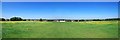
Latton Common
Latton Common http://www.wildessex.net/sites/Harlow%20Latton%20Commons.htm is managed in conjunction with Image; the two sites are bisected by the A414 but there is an underpass that links the sites. The Forest Way long distance path bears off towards the left of the panorama.
Image: © Glyn Baker
Taken: 26 May 2017
0.21 miles
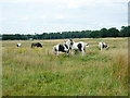
6
Grazing on Latton Common
It seems people are exercising their commoners rights to grazing on Image
Image: © Glyn Baker
Taken: 26 May 2017
0.22 miles
7
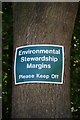
Made Me Fume!
Have a look at what the farmer gets a tax payer subsidy for at Image
Image: © Glyn Baker
Taken: 26 May 2017
0.23 miles