IMAGES TAKEN NEAR TO
Southern Way, HARLOW, CM18 7BH
Introduction
This page details the photographs taken nearby to Southern Way, CM18 7BH by members of the Geograph project.
The Geograph project started in 2005 with the aim of publishing, organising and preserving representative images for every square kilometre of Great Britain, Ireland and the Isle of Man.

There are currently over 7.5m images from over14,400 individuals and you can help contribute to the project by visiting https://www.geograph.org.uk
Image Map
Images are licensed for reuse under creativecommons.org/licenses/by-sa/2.0
Notes
- Clicking on the map will re-center to the selected point.
- The higher the marker number, the further away the image location is from the centre of the postcode.
Image Listing (5 Images Found)
Images are licensed for reuse under creativecommons.org/licenses/by-sa/2.0
Image
Details
Distance
1
Looking South from Bishopsfield.
This was taken from one of the many high points in Bishopsfield and shows the view towards Epping.
Image: © Hazel
Taken: 29 Jul 2002
0.19 miles
2
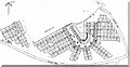
Blueprint of Bishopsfield
This is why Bishopsfield was nicknamed the HORSESHOE estate for many years.
Image: © Hazel
Taken: 27 Feb 1979
0.19 miles
3
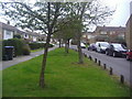
Tysea Road at the corner of Wharley Hook
These are the standard council type houses in Harlow but far from the general design unlike many other new towns. These were probably built towards the beginning of construction around the late 1950s
Image: © David Howard
Taken: 12 Apr 2012
0.20 miles
4
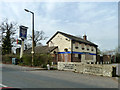
The Chequers (closed)
On Commonside Road, Harlow. The estate agent's sign says 'Sold'.
Image: © Robin Webster
Taken: 20 Mar 2014
0.21 miles