IMAGES TAKEN NEAR TO
Tilbury Mead, HARLOW, CM18 6JQ
Introduction
This page details the photographs taken nearby to Tilbury Mead, CM18 6JQ by members of the Geograph project.
The Geograph project started in 2005 with the aim of publishing, organising and preserving representative images for every square kilometre of Great Britain, Ireland and the Isle of Man.

There are currently over 7.5m images from over14,400 individuals and you can help contribute to the project by visiting https://www.geograph.org.uk
Image Map (Loading...)


Getting Data...Please wait
Leaflet Map data © OpenStreetMap
Images are licensed for reuse under creativecommons.org/licenses/by-sa/2.0
Notes
- Clicking on the map will re-center to the selected point.
- The higher the marker number, the further away the image location is from the centre of the postcode.
Image Listing (9 Images Found)
Images are licensed for reuse under creativecommons.org/licenses/by-sa/2.0
Image
Details
Distance
2
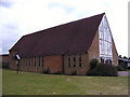
Holy Cross RC Church Harlow Essex
Situated in Tracyes Road.
Image: © Peter Stack
Taken: 7 Jun 2009
0.11 miles
3
Harlow: the Co-op, Tumbler Road, on a winter evening
Approaching four and the light is fading, on a bitter afternoon not long before the shortest day.
Image: © Christopher Hilton
Taken: 18 Dec 2011
0.16 miles
4
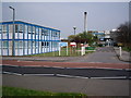
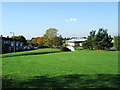
Brays Grove School
Brays Grove is a mixed secondary school of non denomination.
Image: © Lynda Poulter
Taken: 12 Apr 2007
0.16 miles
5
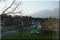
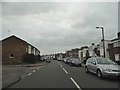
Harlow: Tumbler Road looking north, from an upstairs window on Manor Hatch Close
Image: © Christopher Hilton
Taken: 18 Dec 2011
0.18 miles
6
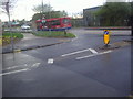
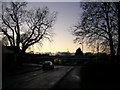
Brooklane Field at the junction of Southern Way
Image: © David Howard
Taken: 12 Apr 2012
0.20 miles
8
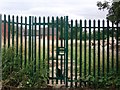
Little Pynchons.
Field adjacent to Little Pynchons. Keats House Surgery and underpass
Image: © John Plumb
Taken: 19 Oct 2007
0.22 miles
9
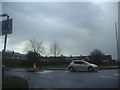
Junction of Southern Way and Tilliwicks Road
During the April showers
Image: © David Howard
Taken: 12 Apr 2012
0.22 miles