IMAGES TAKEN NEAR TO
Waterhouse Moor, HARLOW, CM18 6BG
Introduction
This page details the photographs taken nearby to Waterhouse Moor, CM18 6BG by members of the Geograph project.
The Geograph project started in 2005 with the aim of publishing, organising and preserving representative images for every square kilometre of Great Britain, Ireland and the Isle of Man.

There are currently over 7.5m images from over14,400 individuals and you can help contribute to the project by visiting https://www.geograph.org.uk
Image Map (Loading...)


Getting Data...Please wait
Leaflet Map data © OpenStreetMap
Images are licensed for reuse under creativecommons.org/licenses/by-sa/2.0
Notes
- Clicking on the map will re-center to the selected point.
- The higher the marker number, the further away the image location is from the centre of the postcode.
Image Listing (5 Images Found)
Images are licensed for reuse under creativecommons.org/licenses/by-sa/2.0
Image
Details
Distance
1
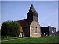
St Andrews Community learning Centre
This church building is now used as a learning centre. The Black building on the right is The Hummingbird Public House.
Image: © Lynda Poulter
Taken: 14 Apr 2007
0.09 miles
2
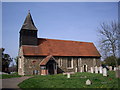
St. Andrews Community Learning Centre
This pretty little church is now being used as a learning centre.
Image: © Lynda Poulter
Taken: 14 Apr 2007
0.09 miles
3
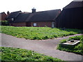
The Harlow Study Centre
The study centre is adjacent to the learning centre.
Image: © Lynda Poulter
Taken: 14 Apr 2007
0.13 miles
4
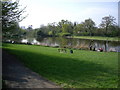
Netteswell Pond
Netteswell Pond beside Second Avenue is a pretty and relaxing place to sit, fish, play or just sunbathe. It was originally used by the monks as a fishery.
Image: © Lynda Poulter
Taken: 14 Apr 2007
0.17 miles
5
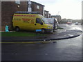
The corner of Little Brays and Tumbler Road
Image: © David Howard
Taken: 12 Apr 2012
0.23 miles