IMAGES TAKEN NEAR TO
Westfield, HARLOW, CM18 6AR
Introduction
This page details the photographs taken nearby to Westfield, CM18 6AR by members of the Geograph project.
The Geograph project started in 2005 with the aim of publishing, organising and preserving representative images for every square kilometre of Great Britain, Ireland and the Isle of Man.

There are currently over 7.5m images from over14,400 individuals and you can help contribute to the project by visiting https://www.geograph.org.uk
Image Map (8 Images)


Getting Data...Please wait
Leaflet Map data © OpenStreetMap
Images are licensed for reuse under creativecommons.org/licenses/by-sa/2.0
Notes
- Clicking on the map will re-center to the selected point.
- The higher the marker number, the further away the image location is from the centre of the postcode.
Image Listing (8 Images Found)
Images are licensed for reuse under creativecommons.org/licenses/by-sa/2.0
Image
Details
Distance
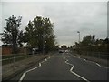
1
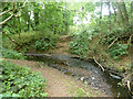
Todd Brook, Harlow
Here more or less running along the edge of the wood called Netteswell Plantation.
Image: © Robin Webster
Taken: 25 Jun 2015
0.14 miles
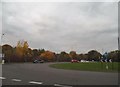
3
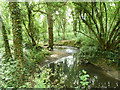
Todd Brook, Harlow
A sylvan scene surprisingly close to Harlow town centre.
Image: © Robin Webster
Taken: 25 Jun 2015
0.22 miles
4
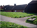
The Harlow Study Centre
The study centre is adjacent to the learning centre.
Image: © Lynda Poulter
Taken: 14 Apr 2007
0.23 miles
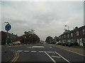
7
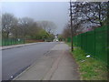
Tendring Road, Passmores
There are schools either side of the railings, and you can just see the road ahead has been blocked at some point since my map was published decades ago.
Image: © David Howard
Taken: 12 Apr 2012
0.25 miles
8
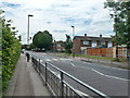
Zebra crossing and railings, Tye Green, Harlow
On Tawneys Road, not hugely busy (at least off peak), but there is a school behind the hedge on the left, so these are probably here because of that.
Image: © Robin Webster
Taken: 25 Jun 2015
0.25 miles