IMAGES TAKEN NEAR TO
Meon Close, CHELMSFORD, CM1 7QG
Introduction
This page details the photographs taken nearby to Meon Close, CM1 7QG by members of the Geograph project.
The Geograph project started in 2005 with the aim of publishing, organising and preserving representative images for every square kilometre of Great Britain, Ireland and the Isle of Man.

There are currently over 7.5m images from over14,400 individuals and you can help contribute to the project by visiting https://www.geograph.org.uk
Image Map
Images are licensed for reuse under creativecommons.org/licenses/by-sa/2.0
Notes
- Clicking on the map will re-center to the selected point.
- The higher the marker number, the further away the image location is from the centre of the postcode.
Image Listing (4 Images Found)
Images are licensed for reuse under creativecommons.org/licenses/by-sa/2.0
Image
Details
Distance
1
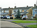
Houses on Humber Road
These were built with no forward extension and a separate garage to the right, which now has been absorbed into the house. The house to the left was extended first, then the central one (when I lived there). It has later been extended further.
Image: © Robin Webster
Taken: 11 Dec 2012
0.20 miles
2
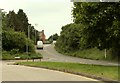
Lawn Lane in Springfield
The turning on the left is Waveney Drive.
Image: © Robert Edwards
Taken: 30 May 2008
0.21 miles
3

The Boswells School in Springfield
This comprehensive school stands in Burnham Road.
Image: © Robert Edwards
Taken: 7 Feb 2009
0.23 miles
4
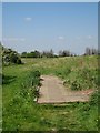
Springfield Hall Park
Recreation ground by the riverbank
Image: © John Myers
Taken: 6 May 2008
0.24 miles