IMAGES TAKEN NEAR TO
Arbour Lane, CHELMSFORD, CM1 7PL
Introduction
This page details the photographs taken nearby to Arbour Lane, CM1 7PL by members of the Geograph project.
The Geograph project started in 2005 with the aim of publishing, organising and preserving representative images for every square kilometre of Great Britain, Ireland and the Isle of Man.

There are currently over 7.5m images from over14,400 individuals and you can help contribute to the project by visiting https://www.geograph.org.uk
Image Map
Images are licensed for reuse under creativecommons.org/licenses/by-sa/2.0
Notes
- Clicking on the map will re-center to the selected point.
- The higher the marker number, the further away the image location is from the centre of the postcode.
Image Listing (12 Images Found)
Images are licensed for reuse under creativecommons.org/licenses/by-sa/2.0
Image
Details
Distance
1
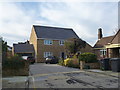
New house, Dalrymple Close, Chelmsford
Image: © Alex McGregor
Taken: 18 Jan 2012
0.06 miles
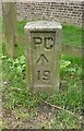
2
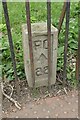
Old Boundary Marker on the B1137 Springfield Road, Chelmsford
Prison Commission Boundary Marker behind railings on the southeast side of the B1137 Springfield Road, Chelmsford. Marking the northeast boundary of Chelmsford Prison.
Milestone Society National ID: EX_PCCHEL22em
Image: © M Bardell
Taken: 16 Mar 2022
0.13 miles
3
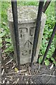
Old Boundary Marker on Sandford Road, Chelmsford
Prison Commission Boundary Marker behind railings on the south side of Sandford Road, Chelmsford. Marking the northeast boundary of Chelmsford Prison.
Milestone Society National ID: EX_PCCHEL21em
Image: © M Bardell
Taken: 16 Mar 2022
0.13 miles
4
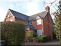
New house, Springfield Road, Chelmsford
Image: © Alex McGregor
Taken: 18 Jan 2012
0.13 miles
5
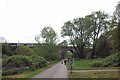
Chelmer Valley LNR
This is the Chelmer Valley Local Nature Nature Reserve http://www.essexinfo.net/chelmervalley/just a stones throw from the centre of town.
Image: © Glyn Baker
Taken: 13 Apr 2017
0.14 miles
7
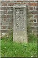
Old Boundary Marker on Sanford Road, Chelmsford
Prison Commission Boundary Marker at the foot of the prison wall on the south side of Sandford Road, Chelmsford. Marking the northeast boundary of Chelmsford Prison.
Milestone Society National ID: EX_PCCHEL20em
Image: © M Bardell
Taken: 16 Mar 2022
0.17 miles
8
Old Boundary Marker on Sanford Road, Chelmsford
Prison Commission Boundary Marker against a struggling wooden fence fencing off a grass triangle at the foot of the prison wall on the south side of Sandford Road, Chelmsford. Marking the northeast boundary of Chelmsford Prison.
Milestone Society National ID: EX_PCCHEL19em
Image: © M Bardell
Taken: 16 Mar 2022
0.17 miles
9
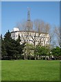
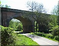
Essex Police HQ, Springfield, Chelmsford
Vaguely Orwellian structure.
Image: © John Myers
Taken: 6 May 2008
0.22 miles
10
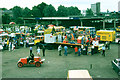
Chelmsford carnival musters at the livestock market, 1980
Beyond the market to the left is the River Chelmer, and beyond on the right, Victoria Road. The open vehicle in the foreground is a fire engine of the Marconi Fire Brigade, although probably not operational as such by 1980. The livestock market later moved out of town, but closed in 1999. I am at a loss to remember the fairly elevated vantage point!
Image: © Robin Webster
Taken: Unknown
0.24 miles