IMAGES TAKEN NEAR TO
Ayletts, CHELMSFORD, CM1 7LE
Introduction
This page details the photographs taken nearby to Ayletts, CM1 7LE by members of the Geograph project.
The Geograph project started in 2005 with the aim of publishing, organising and preserving representative images for every square kilometre of Great Britain, Ireland and the Isle of Man.

There are currently over 7.5m images from over14,400 individuals and you can help contribute to the project by visiting https://www.geograph.org.uk
Image Map (Loading...)


Getting Data...Please wait
Leaflet Map data © OpenStreetMap
Images are licensed for reuse under creativecommons.org/licenses/by-sa/2.0
Notes
- Clicking on the map will re-center to the selected point.
- The higher the marker number, the further away the image location is from the centre of the postcode.
Image Listing (7 Images Found)
Images are licensed for reuse under creativecommons.org/licenses/by-sa/2.0
Image
Details
Distance
1
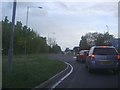
Blasford Hill at the junction of Hospital Approach
Turn right for Broomfield hospital
Image: © David Howard
Taken: 15 May 2012
0.07 miles
2
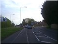
Blasford Hill at the junction of Hospital Approach
Image: © David Howard
Taken: 15 May 2012
0.11 miles
3
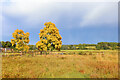
Butler's Farm
Trees near the B1008 near Broomfield.
Image: © Wayland Smith
Taken: 3 Oct 2021
0.16 miles
4
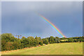
Rainbow near Broomfield
View towards Croxtons Mill.
Image: © Wayland Smith
Taken: 3 Oct 2021
0.22 miles
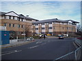
5

New Entrance, Broomfield Hospital, Chelmsford, Essex
Image: © Peter Stack
Taken: 21 Jan 2011
0.23 miles
6
East Entrance, Broomfield Hospital
Will the building work ever be complete? Like Wembley Stadium it goes on and on and on! At least it should look nice when it's done!
Image: © John Myers
Taken: 13 Mar 2007
0.23 miles
7
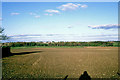
View east from Main Road, Broomfield, 1981
Distant across the Chelmer are Alder Carr and Newland Grove nature reserves, and beyond gravel pit buildings.
Image: © Robin Webster
Taken: Unknown
0.24 miles