IMAGES TAKEN NEAR TO
School Lane, CHELMSFORD, CM1 7DN
Introduction
This page details the photographs taken nearby to School Lane, CM1 7DN by members of the Geograph project.
The Geograph project started in 2005 with the aim of publishing, organising and preserving representative images for every square kilometre of Great Britain, Ireland and the Isle of Man.

There are currently over 7.5m images from over14,400 individuals and you can help contribute to the project by visiting https://www.geograph.org.uk
Image Map
Images are licensed for reuse under creativecommons.org/licenses/by-sa/2.0
Notes
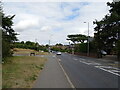
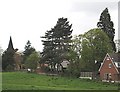
- Clicking on the map will re-center to the selected point.
- The higher the marker number, the further away the image location is from the centre of the postcode.
Image Listing (15 Images Found)
Images are licensed for reuse under creativecommons.org/licenses/by-sa/2.0
Image
Details
Distance
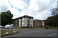
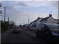
2
Main Road, Broomfield
The public library is behind the trees on the left
Image: © David Howard
Taken: 15 May 2012
0.06 miles
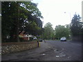
4
The entrance to Bridgemarsh care home, Main Road
Image: © David Howard
Taken: 15 May 2012
0.07 miles
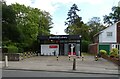
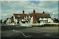
6
Angel PH, Broomfield, Chelmsford, Essex
Image: © Peter Stack
Taken: 21 Jan 2011
0.09 miles
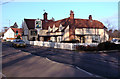
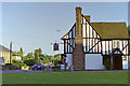
7
'The Angel' inn, Broomfield, Essex
This inn stands on the B1008 between Chelmsford and Braintree, in Broomfield village. It has been an inn for many years and parts of the building are at least 400 years old.
Image: © Robert Edwards
Taken: 28 May 2006
0.10 miles
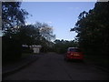
9
The edge of Broomfield
The Centenary Circle path emerges into countryside
Image: © John Myers
Taken: 29 Apr 2008
0.22 miles
10
The King's Arms, Broomfield, 1988
Looking across the green.
Image: © Robin Webster
Taken: Unknown
0.23 miles