IMAGES TAKEN NEAR TO
Barnfield Way, HARLOW, CM17 9TN
Introduction
This page details the photographs taken nearby to Barnfield Way, CM17 9TN by members of the Geograph project.
The Geograph project started in 2005 with the aim of publishing, organising and preserving representative images for every square kilometre of Great Britain, Ireland and the Isle of Man.

There are currently over 7.5m images from over14,400 individuals and you can help contribute to the project by visiting https://www.geograph.org.uk
Image Map
Images are licensed for reuse under creativecommons.org/licenses/by-sa/2.0
Notes
- Clicking on the map will re-center to the selected point.
- The higher the marker number, the further away the image location is from the centre of the postcode.
Image Listing (6 Images Found)
Images are licensed for reuse under creativecommons.org/licenses/by-sa/2.0
Image
Details
Distance
1
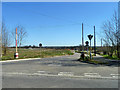
New road - 'Works traffic only'
Formerly an unmade track to the Essex Hunt Kennels and Cottages, there seems to be some development afoot.
Image: © Robin Webster
Taken: 16 Mar 2014
0.16 miles
2
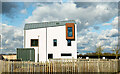
Newhall House Architecture
Part of the Newhall Development. Some of it is very 'Marmite'!!!
Image: © John Allen
Taken: 27 Feb 2020
0.17 miles
3
The Chase
The new housing estate being built between Old Harlow and Church Langley.
Image: © Lynda Poulter
Taken: 14 Apr 2007
0.18 miles
4

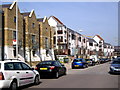
10-16 The Chase, New Hall, Harlow
A terrace of modern three storey houses, newly completed when this photo was taken.
Image: © John Brightley
Taken: 13 May 2004
0.21 miles
5
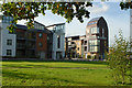
Newhall Farm housing development
Some of the award winning architecture.
Image: © John Allen
Taken: 12 Oct 2006
0.21 miles
6

5-8 The Chase, New Hall, Harlow
A terrace of modern town houses.
Image: © John Brightley
Taken: 13 May 2004
0.22 miles