IMAGES TAKEN NEAR TO
Rosefield Lane, HARLOW, CM17 9SE
Introduction
This page details the photographs taken nearby to Rosefield Lane, CM17 9SE by members of the Geograph project.
The Geograph project started in 2005 with the aim of publishing, organising and preserving representative images for every square kilometre of Great Britain, Ireland and the Isle of Man.

There are currently over 7.5m images from over14,400 individuals and you can help contribute to the project by visiting https://www.geograph.org.uk
Image Map (Loading...)


Getting Data...Please wait
Leaflet Map data © OpenStreetMap
Images are licensed for reuse under creativecommons.org/licenses/by-sa/2.0
Notes
- Clicking on the map will re-center to the selected point.
- The higher the marker number, the further away the image location is from the centre of the postcode.
Image Listing (3 Images Found)
Images are licensed for reuse under creativecommons.org/licenses/by-sa/2.0
Image
Details
Distance
1
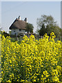
The Round House
A late 18th century 'lodge cottage'. This is a timber framed house.
Image: © John Allen
Taken: 19 Apr 2007
0.11 miles
2
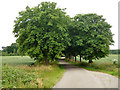
An avenue of trees
The final part of the private road to Hubbard's Hall is lined with Horse Chestnuts. It is a public footpath.
Image: © Robin Webster
Taken: 25 Jun 2015
0.21 miles
3
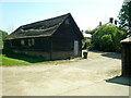
Barn at Newhall Farm
The main house for Newhall Farm is the building in the background
Image: © John Allen
Taken: 19 Apr 2007
0.21 miles