IMAGES TAKEN NEAR TO
Elwood, HARLOW, CM17 9QL
Introduction
This page details the photographs taken nearby to Elwood, CM17 9QL by members of the Geograph project.
The Geograph project started in 2005 with the aim of publishing, organising and preserving representative images for every square kilometre of Great Britain, Ireland and the Isle of Man.

There are currently over 7.5m images from over14,400 individuals and you can help contribute to the project by visiting https://www.geograph.org.uk
Image Map
Images are licensed for reuse under creativecommons.org/licenses/by-sa/2.0
Notes
- Clicking on the map will re-center to the selected point.
- The higher the marker number, the further away the image location is from the centre of the postcode.
Image Listing (11 Images Found)
Images are licensed for reuse under creativecommons.org/licenses/by-sa/2.0
Image
Details
Distance
1
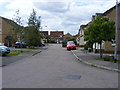
Albert Gardens, Church Langley, Harlow.
Image: © Stuart Shepherd
Taken: 2 Aug 2009
0.12 miles
2
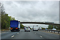
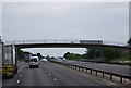
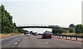
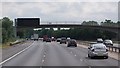
Footbridge over the M11
A flat concrete arch, much more elegant than the road bridges.
Image: © Robin Webster
Taken: 7 Oct 2011
0.21 miles

9
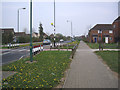
Church Langley Way
Church Langley, Harlow.
Image: © Lynda Poulter
Taken: 12 Apr 2007
0.22 miles
10
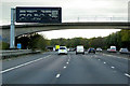
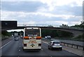
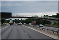
Variable Message Sign and Footbridge, M11 near to Foster Street
A variable message sign (VMS), also sometimes referred to as a matrix sign, is an electronic traffic sign used on motorways (and some other major routes) to give drivers information about special events and to warn them about traffic congestion, accidents, incidents, roadworks or speed limits on specific sections of the route. The signs may also suggest (or instruct) drivers to take alternative routes, limit speed, warn of duration and location of the incidents or just inform of the traffic conditions.
Image: © David Dixon
Taken: 28 Oct 2018
0.23 miles