IMAGES TAKEN NEAR TO
Burley Hill, HARLOW, CM17 9QH
Introduction
This page details the photographs taken nearby to Burley Hill, CM17 9QH by members of the Geograph project.
The Geograph project started in 2005 with the aim of publishing, organising and preserving representative images for every square kilometre of Great Britain, Ireland and the Isle of Man.

There are currently over 7.5m images from over14,400 individuals and you can help contribute to the project by visiting https://www.geograph.org.uk
Image Map (Loading...)


Getting Data...Please wait
Leaflet Map data © OpenStreetMap
Images are licensed for reuse under creativecommons.org/licenses/by-sa/2.0
Notes
- Clicking on the map will re-center to the selected point.
- The higher the marker number, the further away the image location is from the centre of the postcode.
Image Listing (3 Images Found)
Images are licensed for reuse under creativecommons.org/licenses/by-sa/2.0
Image
Details
Distance
1
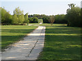
The Bridleway looking South towards Harlow Common
The picture was taken from the southern side of Kiln Lane. The Common is the open space through the gap in the hedgherow in the middle-far distance.
Image: © John Allen
Taken: 20 Apr 2007
0.16 miles
2
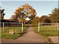
Public bridleway to Kingsdon Lane from Red Lion Lane
Image: © Robert Edwards
Taken: 24 Oct 2008
0.17 miles
3
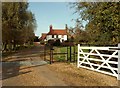
The entrance to Kitchen Hall Farm
A few years ago this farm was surrounded by fields and open countryside, now it is surrounded by new houses except for the southern side that faces Harlow Common.
Image: © Robert Edwards
Taken: 24 Oct 2008
0.21 miles