IMAGES TAKEN NEAR TO
Mill Street, HARLOW, CM17 9JE
Introduction
This page details the photographs taken nearby to Mill Street, CM17 9JE by members of the Geograph project.
The Geograph project started in 2005 with the aim of publishing, organising and preserving representative images for every square kilometre of Great Britain, Ireland and the Isle of Man.

There are currently over 7.5m images from over14,400 individuals and you can help contribute to the project by visiting https://www.geograph.org.uk
Image Map
Images are licensed for reuse under creativecommons.org/licenses/by-sa/2.0
Notes
- Clicking on the map will re-center to the selected point.
- The higher the marker number, the further away the image location is from the centre of the postcode.
Image Listing (16 Images Found)
Images are licensed for reuse under creativecommons.org/licenses/by-sa/2.0
Image
Details
Distance
2
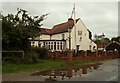
'The Horns & Horseshoes' inn at Foster Street, Essex
Image: © Robert Edwards
Taken: 29 Sep 2006
0.12 miles
3
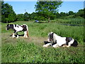
Horses alongside Foster Street
The right hand horse had just woken up.
Image: © Marathon
Taken: 27 Jun 2015
0.13 miles
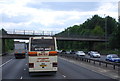
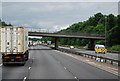
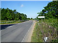
5
M11 Motorway bridge near Harlow
The bridge carries Harlow common Road. A water tower can be seen in the distance.
Image: © Julian P Guffogg
Taken: 4 May 2013
0.13 miles
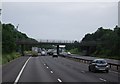
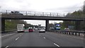
6
Bridge over the M11
Foster Street becomes Harlow Common here as it crosses the M11 just beyond the turn for Hastingwood.
Image: © Marathon
Taken: 27 Jun 2015
0.13 miles
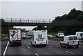
7

M11 - Foster Street bridge
The marker sign coincidentally close to the bridge gives a distance of 32.9 km from the M11 datum.
Image: © Robin Webster
Taken: 7 Oct 2011
0.14 miles